NASA sees Tropical Cyclone Bruce develop near Cocos Island
The infrared instrument aboard NASA's Aqua satellite clearly shows the developing eye in Tropical Cyclone Bruce on Dec. 18 at 07:23 UTC/2:23 a.m. EST.<br><br>Credit: NASA JPL/Ed Olsen<br>
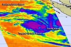
The MODIS or Moderate Resolution Imaging Spectroradiometer instrument that flies aboard NASA's Aqua satellite captured Tropical Cyclone Bruce's developing eye in a visible image taken on Dec. 18 at 07:30 UTC/2:30 a.m. EST.
Animated multispectral satellite imagery showed that the low-level circulation center was consolidating and there was an improvement in the banding of thunderstorms around the elongated center. The Atmospheric Infrared Sounder instrument that also flies aboard Aqua more clearly showed the developing eye.
The infrared data showed cloud top temperatures, and around the center cloud tops were as cold as -63F/-52C, while the center was devoid of high, cold clouds, providing a more clear indication of a developing eye.
When NASA's Tropical Rainfall Measuring Mission or TRMM satellite passed over Bruce on Dec. 18 at 407 UTC/Dec. 17 at 11:07 p.m. EST, data showed that the bands of thunderstorms were fragmented, but tightly wrapped into the center.
On December 18 at 0900 UTC/4 a.m. EST, Tropical Cyclone Bruce had maximum sustained winds near 50 knots/57.5 mph/92.6 kph making it a tropical storm. Bruce is expected to strengthen over the next several days and reach hurricane/typhoon strength before weakening. Bruce was centered just 108 nautical miles/124.3 miles/200 km northwest of Cocos Island, near 10.9 south latitude and 95.5 east longitude. It was moving to the southwest at 9 knots/10.3 mph/16.6 kph.
The Australian Bureau of Meteorology noted on December 18 at 11:00 a.m. EST, that winds affecting the Cocos Islands eased below gale force as Tropical Cyclone Bruce continues moving away.
Bruce is expected to track to the west-southwest and intensify over the next couple of days as it moves over open ocean.
Media Contact
More Information:
http://www.nasa.govAll latest news from the category: Earth Sciences
Earth Sciences (also referred to as Geosciences), which deals with basic issues surrounding our planet, plays a vital role in the area of energy and raw materials supply.
Earth Sciences comprises subjects such as geology, geography, geological informatics, paleontology, mineralogy, petrography, crystallography, geophysics, geodesy, glaciology, cartography, photogrammetry, meteorology and seismology, early-warning systems, earthquake research and polar research.


Newest articles

Silicon Carbide Innovation Alliance to drive industrial-scale semiconductor work
Known for its ability to withstand extreme environments and high voltages, silicon carbide (SiC) is a semiconducting material made up of silicon and carbon atoms arranged into crystals that is…

New SPECT/CT technique shows impressive biomarker identification
…offers increased access for prostate cancer patients. A novel SPECT/CT acquisition method can accurately detect radiopharmaceutical biodistribution in a convenient manner for prostate cancer patients, opening the door for more…

How 3D printers can give robots a soft touch
Soft skin coverings and touch sensors have emerged as a promising feature for robots that are both safer and more intuitive for human interaction, but they are expensive and difficult…

