NASA sees System 93L explode into Tropical Storm Gordon
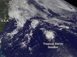
The GOES-13 satellite captured this visible image of newborn Tropical Storm Gordon on Aug. 16 at 1145 UTC (7:45 a.m. EDT). Credit: NASA GOES Project<br>
System 93L started out on August 10 as a tropical wave and associated low pressure area, that moved off the African coast into the eastern Atlantic. Over the last six days it moved west across the Atlantic Ocean and had its ups and downs in terms of organization and development.
On August 15 at 5 p.m. EDT, it strengthened into the Atlantic Ocean hurricane season's eighth tropical depression, just 15 hours after infrared data from the Atmospheric Infrared Sounder (AIRS) instrument onboard NASA's Aqua satellite identified a strong banding of thunderstorms around the center of circulation and northwest of the center. That banding was an indication of organization and strengthening.
Aqua's AIRS instrument captured another infrared image System 93L as it was strengthening into tropical depression 8, and before it became Tropical Storm Gordon. The image was taken on Aug. 15 at 12:53 p.m. EDT, and showed strong bands of thunderstorms to the north and west of the center of circulation where cloud tops were so high into the atmosphere that they were as cold as -63 Fahrenheit (-52 Celsius). When thunderstorms that make up tropical cyclones reach such heights, they likely contain heavy rainfall, and are indicative of a lot of strength within the cyclone.
Tropical Depression 8 continued to intensify and by August 16, it had strengthened into Tropical Storm Gordon, the seventh tropical storm of the Atlantic Ocean hurricane season.
At 5 a.m. EDT, Tropical Storm Gordon had maximum sustained wind near 40 mph (65 kmh), and some strengthening is expected, according to the National Hurricane Center (NHC). In fact, the NHC noted that Gordon could become a hurricane over the weekend of August 18-19 because the storm is expected to track over warm water and encounter very little wind shear.
The center of Tropical Storm Gordon was located about 585 miles (940 km) east of Bermuda, near latitude 32.2 north and longitude 54.8 west. Gordon is moving toward the north-northeast near 14 mph (22 kmh) and is expected to turn northeast and east, heading back into the north central Atlantic Ocean.
The NOAA GOES-13 satellite captured a visible image of newborn Tropical Storm Gordon on August 16 at 1145 UTC (7:45 a.m. EDT). The image shows that Gordon is a small storm. Tropical-storm-force winds extend outward from the center to only 25 miles (35 km) and those are mostly east of the center of circulation. The GOES-13 image shows that small central dense overcast has formed near Gordon's center. The image was created at NASA GOES Project at the NASA Goddard Space Flight Center in Greenbelt, Md. NASA's GOES Project creates images and animations from NOAA GOES satellite data.
The NHC expects Gordon to track east into the Atlantic, and it may affect the Azores.
Media Contact
More Information:
http://www.nasa.govAll latest news from the category: Earth Sciences
Earth Sciences (also referred to as Geosciences), which deals with basic issues surrounding our planet, plays a vital role in the area of energy and raw materials supply.
Earth Sciences comprises subjects such as geology, geography, geological informatics, paleontology, mineralogy, petrography, crystallography, geophysics, geodesy, glaciology, cartography, photogrammetry, meteorology and seismology, early-warning systems, earthquake research and polar research.


Newest articles

Properties of new materials for microchips
… can now be measured well. Reseachers of Delft University of Technology demonstrated measuring performance properties of ultrathin silicon membranes. Making ever smaller and more powerful chips requires new ultrathin…

Floating solar’s potential
… to support sustainable development by addressing climate, water, and energy goals holistically. A new study published this week in Nature Energy raises the potential for floating solar photovoltaics (FPV)…

Skyrmions move at record speeds
… a step towards the computing of the future. An international research team led by scientists from the CNRS1 has discovered that the magnetic nanobubbles2 known as skyrmions can be…

