NASA sees strong thunderstorms still surround Cyclone Iggy's center
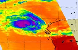
AIRS captured infrared images and cloud temperatures of Tropical Cyclone Iggy on Jan. 31 at 0623 UTC (1:23 a.m. EST). Purple areas indicate the coldest cloud tops and strongest thunderstorms. Most of the strong thunderstorms surround the center of circulation. Credit: NASA/JPL, Ed Olsen<br>
The Atmospheric Infrared Sounder Instrument called AIRS that flies aboard NASA's Aqua satellite captures infrared data and basically takes the temperature of cloud tops in tropical cyclones. That's a critical component of a tropical cyclone because the colder the cloud top, the stronger the uplift and energy in the storm.
The threshold that indicates strongest thunderstorms and highest cloud tops is -63 Fahrenheit (-52.7 Celsius) in AIRS data, and cloud tops around Iggy's center were colder than that. That means there is still a lot of strength in the storm. AIRS data also shows there are tight bands of thunderstorms that are wrapping into the center of the storm. Microwave data from NASA's Aqua satellite showed an eye in the storm, despite its status as a tropical storm.
On January 31 at 1500 UTC (10 a.m. EST) Tropical Cyclone Iggy's maximum sustained winds had decreased to 50 knots ~58 mph/~93 kph). It was located 330 nautical miles (380 miles/611 km) west-southwest of Learmonth, Australia, near 24.5 South latitude and 108.3 East longitude. It is moving to the south-southwest at 13 knots (15 mph/24 kph). The storm is just over 220 nautical miles (~253 miles/~407 km) in diameter.
Iggy has begun moving to the south-southwest, and is expected to curve back later southeast towards southwestern Australia. Current forecasts expect Iggy to weaken as it runs into strong wind shear and cooler waters. Iggy may dissipate before making landfall.
Media Contact
More Information:
http://www.nasa.govAll latest news from the category: Earth Sciences
Earth Sciences (also referred to as Geosciences), which deals with basic issues surrounding our planet, plays a vital role in the area of energy and raw materials supply.
Earth Sciences comprises subjects such as geology, geography, geological informatics, paleontology, mineralogy, petrography, crystallography, geophysics, geodesy, glaciology, cartography, photogrammetry, meteorology and seismology, early-warning systems, earthquake research and polar research.


Newest articles

Superradiant atoms could push the boundaries of how precisely time can be measured
Superradiant atoms can help us measure time more precisely than ever. In a new study, researchers from the University of Copenhagen present a new method for measuring the time interval,…

Ion thermoelectric conversion devices for near room temperature
The electrode sheet of the thermoelectric device consists of ionic hydrogel, which is sandwiched between the electrodes to form, and the Prussian blue on the electrode undergoes a redox reaction…

Zap Energy achieves 37-million-degree temperatures in a compact device
New publication reports record electron temperatures for a small-scale, sheared-flow-stabilized Z-pinch fusion device. In the nine decades since humans first produced fusion reactions, only a few fusion technologies have demonstrated…

