NASA sees some strength in developing Tropical Depression 11W headed for Luzon
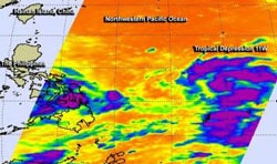
This infrared image from NASA's Aqua satellite on Aug. 8 showed some cloud top temperatures in bands of thunderstorms and around the center of Tropical Depression 11W are as cold as -63F/-52C (purple) indicating strong storms.<br><br>Credit: NASA/JPL<br>
On Aug. 8 at 1853 UTC (2:53 p.m. EDT) NASA's Atmospheric Infrared Sounder or AIRS instrument that flies aboard NASA's Aqua satellite showed some cloud top temperatures in bands of thunderstorms and around the center of Tropical Depression 11W were as cold as -63F/-52C, indicating strong storms.
What does Infrared Data Show?
AIRS infrared images are false-colored to show temperature differences. Scientists look at cloud top temperatures to understand how high the thunderstorms are that make up a tropical cyclone – and there are hundreds of thunderstorms that make up one storm. The colder the cloud top temperature, the higher the top of the thunderstorm reaches into the troposphere and the stronger the storm. NASA research has indicated that cloud top temperatures that reach or exceed the threshold of -63F/-52C typically have heavy rainfall rates.
On Aug. 9 at 1200 UTC (8 a.m. EDT), Tropical Depression 11W's maximum sustained winds near 30 knots/34.5 mph/55.5 kph. 11W's center was located about 671 nautical miles/ 772.2 miles/1,243 km east of Manila, Philippines, near 14.0 north and 132.0 east. 11W is moving west at 10 knots/11.5 mph/18.5 kph. When 11W strengthens into a tropical storm, it will be renamed Tropical Storm Utor.
Forecasters at the Joint Typhoon Warning Center have forecast Tropical Depression 11W's path. After crossing Luzon on Aug. 11 as a tropical storm, 11W is expected to become a typhoon as it moves through the South China Sea on Aug. 12 and 13 before making a landfall in southern China.
Media Contact
More Information:
http://www.nasa.govAll latest news from the category: Earth Sciences
Earth Sciences (also referred to as Geosciences), which deals with basic issues surrounding our planet, plays a vital role in the area of energy and raw materials supply.
Earth Sciences comprises subjects such as geology, geography, geological informatics, paleontology, mineralogy, petrography, crystallography, geophysics, geodesy, glaciology, cartography, photogrammetry, meteorology and seismology, early-warning systems, earthquake research and polar research.


Newest articles

“Nanostitches” enable lighter and tougher composite materials
In research that may lead to next-generation airplanes and spacecraft, MIT engineers used carbon nanotubes to prevent cracking in multilayered composites. To save on fuel and reduce aircraft emissions, engineers…

Trash to treasure
Researchers turn metal waste into catalyst for hydrogen. Scientists have found a way to transform metal waste into a highly efficient catalyst to make hydrogen from water, a discovery that…

Real-time detection of infectious disease viruses
… by searching for molecular fingerprinting. A research team consisting of Professor Kyoung-Duck Park and Taeyoung Moon and Huitae Joo, PhD candidates, from the Department of Physics at Pohang University…

