NASA sees some strength in developing Tropical Depression 11W headed for Luzon
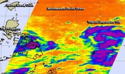
This infrared image from NASA's Aqua satellite on Aug. 8 showed some cloud top temperatures in bands of thunderstorms and around the center of Tropical Depression 11W are as cold as -63F/-52C (purple) indicating strong storms.<br><br>Credit: NASA/JPL<br>
On Aug. 8 at 1853 UTC (2:53 p.m. EDT) NASA's Atmospheric Infrared Sounder or AIRS instrument that flies aboard NASA's Aqua satellite showed some cloud top temperatures in bands of thunderstorms and around the center of Tropical Depression 11W were as cold as -63F/-52C, indicating strong storms.
What does Infrared Data Show?
AIRS infrared images are false-colored to show temperature differences. Scientists look at cloud top temperatures to understand how high the thunderstorms are that make up a tropical cyclone – and there are hundreds of thunderstorms that make up one storm. The colder the cloud top temperature, the higher the top of the thunderstorm reaches into the troposphere and the stronger the storm. NASA research has indicated that cloud top temperatures that reach or exceed the threshold of -63F/-52C typically have heavy rainfall rates.
On Aug. 9 at 1200 UTC (8 a.m. EDT), Tropical Depression 11W's maximum sustained winds near 30 knots/34.5 mph/55.5 kph. 11W's center was located about 671 nautical miles/ 772.2 miles/1,243 km east of Manila, Philippines, near 14.0 north and 132.0 east. 11W is moving west at 10 knots/11.5 mph/18.5 kph. When 11W strengthens into a tropical storm, it will be renamed Tropical Storm Utor.
Forecasters at the Joint Typhoon Warning Center have forecast Tropical Depression 11W's path. After crossing Luzon on Aug. 11 as a tropical storm, 11W is expected to become a typhoon as it moves through the South China Sea on Aug. 12 and 13 before making a landfall in southern China.
Media Contact
More Information:
http://www.nasa.govAll latest news from the category: Earth Sciences
Earth Sciences (also referred to as Geosciences), which deals with basic issues surrounding our planet, plays a vital role in the area of energy and raw materials supply.
Earth Sciences comprises subjects such as geology, geography, geological informatics, paleontology, mineralogy, petrography, crystallography, geophysics, geodesy, glaciology, cartography, photogrammetry, meteorology and seismology, early-warning systems, earthquake research and polar research.


Newest articles

Machine learning algorithm reveals long-theorized glass phase in crystal
Scientists have found evidence of an elusive, glassy phase of matter that emerges when a crystal’s perfect internal pattern is disrupted. X-ray technology and machine learning converge to shed light…

Mapping plant functional diversity from space
HKU ecologists revolutionize ecosystem monitoring with novel field-satellite integration. An international team of researchers, led by Professor Jin WU from the School of Biological Sciences at The University of Hong…

Inverters with constant full load capability
…enable an increase in the performance of electric drives. Overheating components significantly limit the performance of drivetrains in electric vehicles. Inverters in particular are subject to a high thermal load,…

