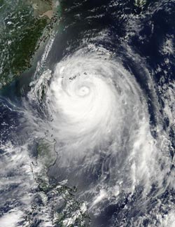
NASA sees Soulik's eye reopen on Taiwan approach

On July 12 at 05:05 UTC (1:05 a.m. EDT) the MODIS instrument aboard NASA's Aqua satellite captured this stunning visible image of Tropical Typhoon Soulik approaching Taiwan.<br><br>Credit: NASA Goddard MODIS Rapid Response<br>
On July 12 at 05:05 UTC (1:05 a.m. EDT) the Moderate Resolution Imaging Spectroradiometer or MODIS instrument aboard NASA's Aqua satellite captured a visible image of Tropical Typhoon Soulik approaching Taiwan.
The image clearly showed a tight, powerful ring of thunderstorms around Soulik's center with a small eye in the center. Soulik underwent eyewall reconstruction on July 12.
The MODIS imagery also revealed that the clouds and thunderstorms in the northern quadrant were less dense than in the southern quadrant. Multispectral and microwave satellite imagery confirm the visible imagery.
The Joint Typhoon Warning Center noted that multispectral satellite imagery showed Soulik remains organized and has large bands of thunderstorms wrapping around the southern semicircle, and into the storm's center. Microwave satellite imagery however, shows subsidence in the northwestern quadrant of the tropical cyclone. Subsidence is the sinking of air that prevents the development of thunderstorms that make up the tropical cyclone. The combination of these data suggests that the strongest part of the storm is the southern quadrant and the weakest part is the northeast quadrant.
The Joint Typhoon Warning Center noted that Soulik's expected track has shifted slightly to the south, which is not good news for Taiwan. On the projected JTWC track, Soulik's center will cross the top third of the island, south of Taipei on July 12 and 13 before crossing the Taiwan Strait.
According to China's National Meteorological Center (NMC), Soulik will move to the coastal areas of Zhejiang and Fujian. Then it will land in the coastal areas of northern Fujian Province to southern Zhejiang from 12:00 p.m. local time, to the evening of July 13.
On July 12 at 1200 UTC (8 a.m. EDT), Typhoon Soulik's maximum sustained winds were near 90 knots (103 mph/166.7 kph). At that time, Soulik was centered near 23.4 north and 124.3 east, about 253 nautical miles southwest of Kadena Air Base, Japan. Soulik is moving to the west-northwest at 10 knots (11.5 mph/18.5 kph) and generating very rough seas with wave heights to 43 feet (13.1 meters).
The China NMC has issued an orange alert for Taiwan, and northern Fujian Province to southern Zhejiang.
Media Contact
More Information:
http://www.nasa.govAll latest news from the category: Earth Sciences
Earth Sciences (also referred to as Geosciences), which deals with basic issues surrounding our planet, plays a vital role in the area of energy and raw materials supply.
Earth Sciences comprises subjects such as geology, geography, geological informatics, paleontology, mineralogy, petrography, crystallography, geophysics, geodesy, glaciology, cartography, photogrammetry, meteorology and seismology, early-warning systems, earthquake research and polar research.
Newest articles

Superradiant atoms could push the boundaries of how precisely time can be measured
Superradiant atoms can help us measure time more precisely than ever. In a new study, researchers from the University of Copenhagen present a new method for measuring the time interval,…

Ion thermoelectric conversion devices for near room temperature
The electrode sheet of the thermoelectric device consists of ionic hydrogel, which is sandwiched between the electrodes to form, and the Prussian blue on the electrode undergoes a redox reaction…

Zap Energy achieves 37-million-degree temperatures in a compact device
New publication reports record electron temperatures for a small-scale, sheared-flow-stabilized Z-pinch fusion device. In the nine decades since humans first produced fusion reactions, only a few fusion technologies have demonstrated…


