NASA Sees Some Strength Left in Remnants of Tropical Cyclone Gillian
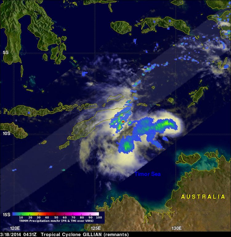
TRMM passed above Gillian's remnants on March 18, 2014 at 0431 UTC and measured rain falling at a rate of over 86 mm/3.4 inches per hour in some intense storms. Image Credit: SSAI/NASA,Hal Pierce
Over the past few days former tropical cyclone Gillian's remnants moved from the Gulf of Carpentaria into the Timor Sea.
The Tropical Rainfall Measuring Mission satellite known as TRMM found a few strong convective thunderstorms when it passed above these remnants on March 18, 2014 at 0431 UTC. TRMM's Precipitation Radar (PR) instrument measured rain falling at a rate of over 86 mm/3.4 inches per hour in some intense storms.
The Joint Typhoon Warning Center or JWTC recently assigned Gillian's remnants a medium chance to regain tropical cyclone status. Asimulated 3-D image was made at NASA's Goddard Space Flight Center in Greenbelt, Md. using TRMM PR data.
The 3-D image showed that several of the tallest thunderstorms in Gillian's remnants were reaching heights of over 15.75 km/9.8 miles. Radar reflectivity values of over 50.7 dBZ were being returned to TRMM from the heavy rainfall within these storms.
The Australian Bureau of Meteorology issued their last statement on Gillian's remnants on March 18 at 10:45 p.m. CST local time/Darwin.
At that time, Ex-Tropical Cyclone Gillian was located 9.6 south latitude and 128.4 east longitude, about 330 km/205.1 miles east southeast of Dili and 525 km/326.2 miles east of Kupang and moving west at 24 kph/38.6 mph.
Gillian's remnants, now in the Southern Indian Ocean basin, are expected to continue moving to the west across the Timor Sea, away from the Northern Territory.
Text credit: Hal Pierce
NASA's Goddard Space Flight Center
Media Contact
All latest news from the category: Earth Sciences
Earth Sciences (also referred to as Geosciences), which deals with basic issues surrounding our planet, plays a vital role in the area of energy and raw materials supply.
Earth Sciences comprises subjects such as geology, geography, geological informatics, paleontology, mineralogy, petrography, crystallography, geophysics, geodesy, glaciology, cartography, photogrammetry, meteorology and seismology, early-warning systems, earthquake research and polar research.


Newest articles

Bringing bio-inspired robots to life
Nebraska researcher Eric Markvicka gets NSF CAREER Award to pursue manufacture of novel materials for soft robotics and stretchable electronics. Engineers are increasingly eager to develop robots that mimic the…

Bella moths use poison to attract mates
Scientists are closer to finding out how. Pyrrolizidine alkaloids are as bitter and toxic as they are hard to pronounce. They’re produced by several different types of plants and are…

AI tool creates ‘synthetic’ images of cells
…for enhanced microscopy analysis. Observing individual cells through microscopes can reveal a range of important cell biological phenomena that frequently play a role in human diseases, but the process of…

