NASA Sees Some Strength Left in Remnants of Tropical Cyclone Gillian
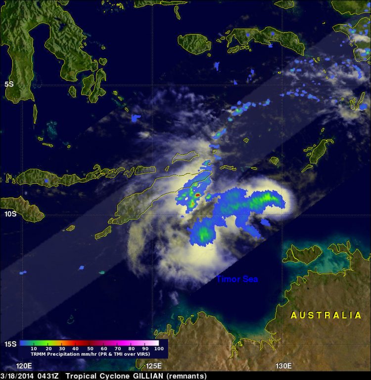
TRMM passed above Gillian's remnants on March 18, 2014 at 0431 UTC and measured rain falling at a rate of over 86 mm/3.4 inches per hour in some intense storms. Image Credit: SSAI/NASA,Hal Pierce
Over the past few days former tropical cyclone Gillian's remnants moved from the Gulf of Carpentaria into the Timor Sea.
The Tropical Rainfall Measuring Mission satellite known as TRMM found a few strong convective thunderstorms when it passed above these remnants on March 18, 2014 at 0431 UTC. TRMM's Precipitation Radar (PR) instrument measured rain falling at a rate of over 86 mm/3.4 inches per hour in some intense storms.
The Joint Typhoon Warning Center or JWTC recently assigned Gillian's remnants a medium chance to regain tropical cyclone status. Asimulated 3-D image was made at NASA's Goddard Space Flight Center in Greenbelt, Md. using TRMM PR data.
The 3-D image showed that several of the tallest thunderstorms in Gillian's remnants were reaching heights of over 15.75 km/9.8 miles. Radar reflectivity values of over 50.7 dBZ were being returned to TRMM from the heavy rainfall within these storms.
The Australian Bureau of Meteorology issued their last statement on Gillian's remnants on March 18 at 10:45 p.m. CST local time/Darwin.
At that time, Ex-Tropical Cyclone Gillian was located 9.6 south latitude and 128.4 east longitude, about 330 km/205.1 miles east southeast of Dili and 525 km/326.2 miles east of Kupang and moving west at 24 kph/38.6 mph.
Gillian's remnants, now in the Southern Indian Ocean basin, are expected to continue moving to the west across the Timor Sea, away from the Northern Territory.
Text credit: Hal Pierce
NASA's Goddard Space Flight Center
Media Contact
All latest news from the category: Earth Sciences
Earth Sciences (also referred to as Geosciences), which deals with basic issues surrounding our planet, plays a vital role in the area of energy and raw materials supply.
Earth Sciences comprises subjects such as geology, geography, geological informatics, paleontology, mineralogy, petrography, crystallography, geophysics, geodesy, glaciology, cartography, photogrammetry, meteorology and seismology, early-warning systems, earthquake research and polar research.


Newest articles

Superradiant atoms could push the boundaries of how precisely time can be measured
Superradiant atoms can help us measure time more precisely than ever. In a new study, researchers from the University of Copenhagen present a new method for measuring the time interval,…

Ion thermoelectric conversion devices for near room temperature
The electrode sheet of the thermoelectric device consists of ionic hydrogel, which is sandwiched between the electrodes to form, and the Prussian blue on the electrode undergoes a redox reaction…

Zap Energy achieves 37-million-degree temperatures in a compact device
New publication reports record electron temperatures for a small-scale, sheared-flow-stabilized Z-pinch fusion device. In the nine decades since humans first produced fusion reactions, only a few fusion technologies have demonstrated…

