NASA sees remnants of Tropical Depression Peipah over Southern Philippines
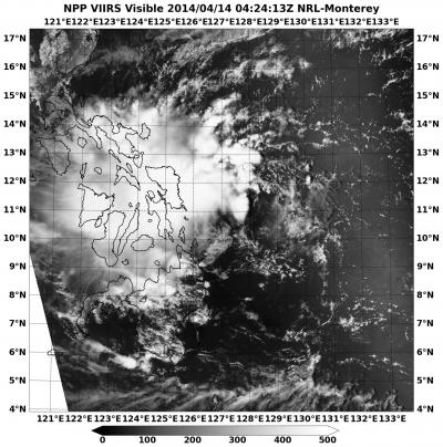
This visible image of Tropical Depression Peipah's remnants over the southern and central Philippines was taken from the VIIRS instrument aboard NASA-NOAA's Suomi NPP satellite on April 14 at 4:24 UTC/12:24. Credit: NRL/NASA/NOAA
NASA-NOAA's Suomi NPP satellite captured an image that showed Peipah's clouds covering the Visayas and Mindanao regions of the country.
The VIIRS instrument aboard NASA-NOAA's Suomi NPP satellite captured a visible look at the remnant clouds associated with former Tropical Depression Peipah on April 14 at 4:24 UTC/12:24 a.m. EDT.
The Visible Infrared Imaging Radiometer Suite (VIIRS) instrument collects visible and infrared imagery and global observations of land, atmosphere, cryosphere and oceans.
Peipah is a broad area of low pressure and its remnant clouds covered the central region of the Philippines called the Visayas region, and Mindanao, the southern region. Microwave satellite imagery confirmed that the low-level part of the storm is still poorly defined and convection (rising air that builds thunderstorms that make up a tropical cyclone) has not improved.
On April 14 at 0900 UTC/5 a.m. EDT, Peipah's remnants were centered near 9.7 north latitude and 130.8 east longitude, about 360 nautical miles/414 miles/666.7 km northwest of Zamboanga, Philippines. Maximum sustained winds were estimated as high as 20 knots/23.0 mph/37.2 kph.
According to the Joint Typhoon Warning Center, Peipah's remnants have a medium chance for regenerating in the next couple of days as it moves slowly in a westerly direction.
Media Contact
More Information:
http://www.nasa.govAll latest news from the category: Earth Sciences
Earth Sciences (also referred to as Geosciences), which deals with basic issues surrounding our planet, plays a vital role in the area of energy and raw materials supply.
Earth Sciences comprises subjects such as geology, geography, geological informatics, paleontology, mineralogy, petrography, crystallography, geophysics, geodesy, glaciology, cartography, photogrammetry, meteorology and seismology, early-warning systems, earthquake research and polar research.


Newest articles

Skyrmions move at record speeds
… a step towards the computing of the future. An international research team led by scientists from the CNRS1 has discovered that the magnetic nanobubbles2 known as skyrmions can be…
A flexible and efficient DC power converter for sustainable-energy microgrids
A new DC-DC power converter is superior to previous designs and paves the way for more efficient, reliable and sustainable energy storage and conversion solutions. The Kobe University development can…
Technical Trials for Easing the (Cosmological) Tension
A new study sorts through models attempting to solve one of the major challenges of contemporary cosmic science, the measurement of its expansion. Thanks to the dizzying growth of cosmic…

