NASA sees more rain for the Philippines from Tropical Storm Kai-Tak
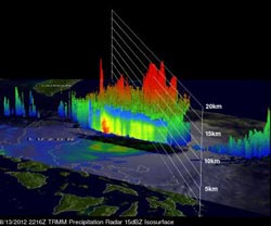
TRMM flew over Kai-tak on Aug. 13, 2012 at 4:16 p.m. EDT and TRMM's Precipitation Radar data were used in a 3-D image to show the vertical scale of the numerous powerful storms near Kai-tak's center. Some convective storms were reaching heights of about 15km (~9.3 miles).<br><br>Credit: Credit: SSAI/NASA, Hal Pierce<br>
Kai-tak has caused another day of warnings in the Philippines. On August 14, Public storm warning signal #1 is in effect for these provinces in Luzon: La Union, Nueva Ecija, Pangasinan, Rest of Aurora, and Tarlac.
In addition, Public storm warning signal #2 has been posted for these Luzon provinces: the Abra and Batanes Group of Islands, Apayao, Benguet; Cagayan (including Calayan and Babuyan Group of Island), Ifugao, Ilocos South and North, Isabela, Kalinga, Mt. Province, Northern Aurora, Nueva Vizcaya, and Quirino.
The Tropical Rainfall Measuring Mission (TRMM) satellite flew over Kai-tak on August 13, 2012 at 2216 UTC 4:16 p.m. EDT). TRMM's Microwave Imager (TMI) and Precipitation Radar (PR) data showed that the tropical storm was dropping extreme amounts of rainfall. TRMM PR revealed that the most intense rainfall of over 100mm/hr. (~3.9 inches) was east of the Philippines over the open waters of the Pacific Ocean. Some light to moderate rainfall from Kai-tak was shown falling on the island of Luzon.
TRMM's Precipitation Radar (PR) data were used in a 3-D image to show the vertical scale of the numerous powerful storms near Kai-tak's center. Some convective storms were reaching heights of about 15km (~9.3 miles).
Tropical storm Kai-tak had maximum sustained winds near 50 knots (57.5 mph/92.6 kmh). It was located about 220 nautical miles (253 miles/407 km) northeast of Manila, Philippines, near 17.4 North latitude and 123.1 East longitude. Kai-tak was moving to the southwest at 10 knots (11.5 mph/18.5 kmh) and is expected to turn to the west-northwest.
Satellite data from August 14 has shown that Kai-tak's low-level center has become more organized. The Atmospheric Infrared Sounder (AIRS) instrument that flies onboard NASA's Aqua satellite showed cooler cloud top temperatures (a sign of more uplift and strength in the storm).
Kai-tak is taking a track across northern Luzon and is expected to move south of Taiwan before making landfall in China.
Media Contact
More Information:
http://www.nasa.govAll latest news from the category: Earth Sciences
Earth Sciences (also referred to as Geosciences), which deals with basic issues surrounding our planet, plays a vital role in the area of energy and raw materials supply.
Earth Sciences comprises subjects such as geology, geography, geological informatics, paleontology, mineralogy, petrography, crystallography, geophysics, geodesy, glaciology, cartography, photogrammetry, meteorology and seismology, early-warning systems, earthquake research and polar research.


Newest articles

Combatting disruptive ‘noise’ in quantum communication
In a significant milestone for quantum communication technology, an experiment has demonstrated how networks can be leveraged to combat disruptive ‘noise’ in quantum communications. The international effort led by researchers…

Stretchable quantum dot display
Intrinsically stretchable quantum dot-based light-emitting diodes achieved record-breaking performance. A team of South Korean scientists led by Professor KIM Dae-Hyeong of the Center for Nanoparticle Research within the Institute for…

Internet can achieve quantum speed with light saved as sound
Researchers at the University of Copenhagen’s Niels Bohr Institute have developed a new way to create quantum memory: A small drum can store data sent with light in its sonic…

