NASA Sees Powerful Thunderstorms in Tropical Storm Matmo
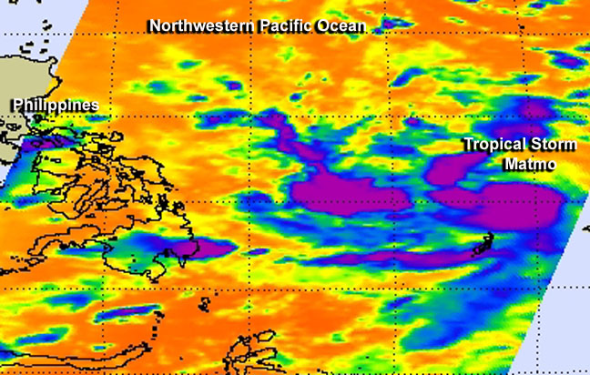
This false-colored infrared image taken on July 17 from NASA's Aqua satellite shows that the concentration of the strongest thunderstorms (purple) around Tropical Storm Matmo's center and a band of thunderstorms west of center. Image Credit: NASA JPL, Ed Olsen
Infrared imagery from NASA's Aqua satellite showed very cold temperatures that indicated the high cloud tops in the powerful storms.
Tropical cyclones consist of hundreds of thunderstorms. When NASA's Aqua satellite flew over Tropical Storm Matmo on July 17 at 16:59 UTC (12:59 p.m. EDT) on July 17, the Atmospheric Infrared Sounder (AIRS) instrument obtained infrared data on the tropical cyclone.
AIRS showed some cloud top temperatures exceeded -63F/-52 C around the storm's center and in the southwestern quadrant of the storm indicating strong storms with the potential for heavy rainfall. The AIRS data was made into a false-colored image at NASA's Jet Propulsion Laboratory in Pasadena, California.
On July 18 at 1500 UTC (11 a.m. EDT) Tropical Storm Matmo's maximum sustained winds were near 40 knots (46 mph/74 kph).
Matmo was located approximately 222 nautical miles (255.5 miles/411.1 km) north of Koror, Palau, centered near 11.2 north latitude and 133.5 east longitude. Matmo has tracked west-northwestward at 3 knots (3.4 mph/5.5 kph).
The Joint Typhoon Warning Center forecast indicates that Matmo will reach typhoon intensity by July 20 as it continues on a northwesterly track toward landfall in northern Taiwan around July 23 as a typhoon.
Text credit: Rob Gutro
NASA's Goddard Space Flight Center
Media Contact
More Information:
http://www.nasa.gov/content/goddard/10w-northwest-pacific-ocean/All latest news from the category: Earth Sciences
Earth Sciences (also referred to as Geosciences), which deals with basic issues surrounding our planet, plays a vital role in the area of energy and raw materials supply.
Earth Sciences comprises subjects such as geology, geography, geological informatics, paleontology, mineralogy, petrography, crystallography, geophysics, geodesy, glaciology, cartography, photogrammetry, meteorology and seismology, early-warning systems, earthquake research and polar research.


Newest articles

Bringing bio-inspired robots to life
Nebraska researcher Eric Markvicka gets NSF CAREER Award to pursue manufacture of novel materials for soft robotics and stretchable electronics. Engineers are increasingly eager to develop robots that mimic the…

Bella moths use poison to attract mates
Scientists are closer to finding out how. Pyrrolizidine alkaloids are as bitter and toxic as they are hard to pronounce. They’re produced by several different types of plants and are…

AI tool creates ‘synthetic’ images of cells
…for enhanced microscopy analysis. Observing individual cells through microscopes can reveal a range of important cell biological phenomena that frequently play a role in human diseases, but the process of…

