NASA sees powerful storms within Tropical Cyclone Ashobaa
On June 8, GPM showed that rain was falling in Ashobaa at a rate of over 70.5 mm (about 2.8 inches) per hour (red) in bands of storms west of the center of circulation. Credits: NASA/JAXA/SSAI, Hal Pierce
The Global Precipitation Measurement (GPM) core observatory had an excellent view of Tropical Cyclone Ashobaa in the Arabian Sea over on June 8, 2015 at 2131 UTC (5:31 p.m. EDT). As expected, Tropical Cyclone Ashobaa was more powerful than when seen by GPM earlier in the day.
GPM's Microwave Imager (GMI) and Dual-Frequency Precipitation Radar (DPR) instruments showed that rain was falling at a rate of over 70.5 mm (about 2.8 inches) per hour in bands of storms west of the center of circulation.
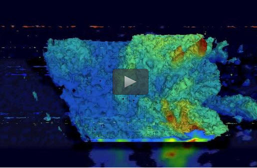
Very powerful storms were seen west of tropical cyclone ASHOBAA's center of circulation by GPM's Ku Band Radar. A 3-D view constructed from GPM's Ku band radar data shows that Tropical Cyclone Ashobaa had some extremely tall storms. GPM radar data indicated that some of these very intense storms were reaching the amazing height of 21 km (13 miles).
On June 10 at 09:00 UTC (5 a.m. EDT), the Moderate Resolution Imaging Spectroradiometer or MODIS instrument aboard NASA's Aqua satellite captured a visible image of Tropical Cyclone Ashobaa off the coast of Oman.
There was no visible eye in the system, although it appears to be strengthening. Bands of thunderstorms were spiraling into the low-level center from the west and east. The MODIS image showed that the northwestern quadrant of the tropical storm was already sweeping over eastern Oman.
The Joint Typhoon Warning Center (JTWC) noted that “Animated multispectral satellite imagery depicts tight spiral banding wrapping beneath a central dense overcast feature that is elongated to the west due to moderate (15-20 knot) easterly vertical wind shear that will persist throughout the forecast period.” Microwave imagery shows disorganized convection along the western edge of the storm, while an eye feature can be seen in microwave data.
By 1500 UTC (11 a.m. EDT), Ashobaa's maximum sustained winds had increased to 55 knots (63.9 mph/ 101.9 kph). Ashobaa was centered near 20.9 North latitude and 61.0 east longitude, about 138 nautical miles (158.8 miles/255.6 km) east-northeast of Masirah Island, Oman. The tropical storm is slowly moving west at 3 knots (3.4 mph/5.5 kph).
The JTWC now expects that Ashobaa will not reach hurricane-strength before making landfall early on June 12 and will weaken quickly thereafter between the interaction with land and dry air that is forecast to move into the circulation.
Media Contact
All latest news from the category: Earth Sciences
Earth Sciences (also referred to as Geosciences), which deals with basic issues surrounding our planet, plays a vital role in the area of energy and raw materials supply.
Earth Sciences comprises subjects such as geology, geography, geological informatics, paleontology, mineralogy, petrography, crystallography, geophysics, geodesy, glaciology, cartography, photogrammetry, meteorology and seismology, early-warning systems, earthquake research and polar research.


Newest articles

Properties of new materials for microchips
… can now be measured well. Reseachers of Delft University of Technology demonstrated measuring performance properties of ultrathin silicon membranes. Making ever smaller and more powerful chips requires new ultrathin…

Floating solar’s potential
… to support sustainable development by addressing climate, water, and energy goals holistically. A new study published this week in Nature Energy raises the potential for floating solar photovoltaics (FPV)…

Skyrmions move at record speeds
… a step towards the computing of the future. An international research team led by scientists from the CNRS1 has discovered that the magnetic nanobubbles2 known as skyrmions can be…

