NASA Sees Odile Soaking Mexico and Southwestern U.S.
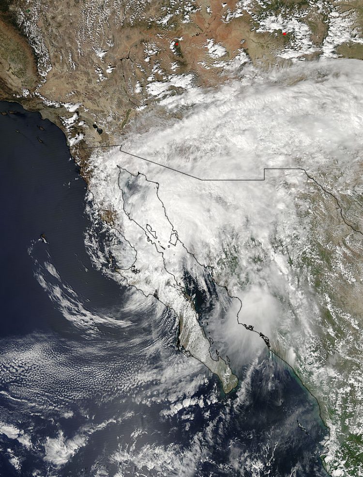
On Sept. 16 at 20:50 UTC (4:50 p.m. EDT) the MODIS instrument aboard NASA's Aqua satellite captured this image of Tropical Storm Odile over Baja California. Image Credit: NASA Goddard MODIS Rapid Response Team
Odile had weakened to a tropical storm with winds of about 55 knots (63.3 mph) when the TRMM satellite flew over on September 16, 2014 at 0917 UTC (2:19 a.m. PDT).
Odile was still well organized and TRMM's Precipitation Radar (PR) measured rain falling at a rate of almost 130 mm (5.1 inches) per hour northeast of the tropical storm's center of circulation. The tops of some strong thunderstorms over the Gulf of California were reaching heights of 13km (8 miles).
On Sept. 17, Odile is weakening as it moves slowly northeastward across the northern Gulf of California while dropping heavy rainfall over portions of northwestern Mexico and the southwestern United States. A Tropical Storm Warning remained in effect for mainland Mexico from Bahia Kino to Puerto Penasco.
At 11 a.m. EDT on Sept. 17, the center of Tropical Storm Odile was located near latitude 30.6 north and longitude 113.3 west, about 50 miles (85 km) south-southeast of Puerto Penasco, Mexico. Odile is moving toward the northeast near 6 mph (9 kph).
On the forecast track the center of Odile is moving into northwestern mainland Mexico. Maximum sustained winds are near 40 mph (65 kph) and rapid weakening is expected as Odile moves over the mainland.
Tropical storm-force winds and heavy amounts of rainfall have been recorded today, Sept. 17. The National Hurricane Center noted that a wind gust to 41 mph (66 kph) was reported at Caborca in the Mexican state of Sonora during the morning hours. A rainfall total of 2.57 inches (62 mm) was observed at Caborca, Mexico.
The heavy rain that TRMM was measuring is expected to continue as Odile tracks slowly over mainland Mexico.
Moisture ahead of Odile is expected to produce rainfall amounts of 3 to 6 inches with isolated totals of 9 inches across southeastern Arizona and southwestern New Mexico, possibly extending into western Texas through Friday, September 19.
Text credit: Rob Gutro
NASA's Goddard Space Flight Center
Media Contact
All latest news from the category: Earth Sciences
Earth Sciences (also referred to as Geosciences), which deals with basic issues surrounding our planet, plays a vital role in the area of energy and raw materials supply.
Earth Sciences comprises subjects such as geology, geography, geological informatics, paleontology, mineralogy, petrography, crystallography, geophysics, geodesy, glaciology, cartography, photogrammetry, meteorology and seismology, early-warning systems, earthquake research and polar research.


Newest articles

Superradiant atoms could push the boundaries of how precisely time can be measured
Superradiant atoms can help us measure time more precisely than ever. In a new study, researchers from the University of Copenhagen present a new method for measuring the time interval,…

Ion thermoelectric conversion devices for near room temperature
The electrode sheet of the thermoelectric device consists of ionic hydrogel, which is sandwiched between the electrodes to form, and the Prussian blue on the electrode undergoes a redox reaction…

Zap Energy achieves 37-million-degree temperatures in a compact device
New publication reports record electron temperatures for a small-scale, sheared-flow-stabilized Z-pinch fusion device. In the nine decades since humans first produced fusion reactions, only a few fusion technologies have demonstrated…

