NASA Sees Newborn Twenty-ninth Depression in the Philippine Sea
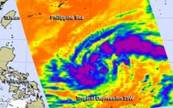
The AIRS instrument aboard NASA's Aqua satellite captured infrared data on Tropical Depression 29W on Oct. 29 at 04:23 UTC/12:23 a.m. EDT and saw strong thunderstorms (purple) west and east of the center. <br>Image Credit: NASA JPL, Ed Olsen<br>
The Philippine Sea is located within the northwestern Pacific Ocean. It's located east and north of the Philippines and covers about 2 million square miles (5 million square kilometers).
The Atmospheric Infrared Sounder or AIRS instrument aboard NASA's Aqua satellite captured infrared data on Tropical Depression 29W on Oct. 29 at 04:23 UTC/12:23 a.m. EDT. AIRS data revealed strong thunderstorms with cloud top temperatures exceeding -63F/-52C that indicated they were high in the troposphere. They thunderstorms appeared in bands west and east of the center. Those thunderstorms were part of bands that formed around the circulation center.
On Oct. 29 at 11 a.m. EDT/1500 UTC, Tropical Depression 29W had maximum sustained winds near 30 knots/34.5 mph/55.5 kph. It was located near 15.7 north and 131.3 east, about 634 nautical miles/729.6 miles/1,174 km east of Manila, Philippines. 29W is moving to the west at 14 knots/16.1 mph/21.3 kph and is expected to continue moving in that general direction over the next couple of days.
Forecasters at the Joint Typhoon Warning Center noted that warm sea surface temperatures in the Philippine Sea (where it is currently moving through) will enable 29W to strengthen into a typhoon in the next one or two days.
29W is expected to move west crossing over Luzon (the northern Philippines) as a tropical storm sometime on Oct. 31 then move into the South China Sea.
Text credit: Rob Gutro
NASA's Goddard Space Flight Center
Media Contact
All latest news from the category: Earth Sciences
Earth Sciences (also referred to as Geosciences), which deals with basic issues surrounding our planet, plays a vital role in the area of energy and raw materials supply.
Earth Sciences comprises subjects such as geology, geography, geological informatics, paleontology, mineralogy, petrography, crystallography, geophysics, geodesy, glaciology, cartography, photogrammetry, meteorology and seismology, early-warning systems, earthquake research and polar research.


Newest articles

Superradiant atoms could push the boundaries of how precisely time can be measured
Superradiant atoms can help us measure time more precisely than ever. In a new study, researchers from the University of Copenhagen present a new method for measuring the time interval,…

Ion thermoelectric conversion devices for near room temperature
The electrode sheet of the thermoelectric device consists of ionic hydrogel, which is sandwiched between the electrodes to form, and the Prussian blue on the electrode undergoes a redox reaction…

Zap Energy achieves 37-million-degree temperatures in a compact device
New publication reports record electron temperatures for a small-scale, sheared-flow-stabilized Z-pinch fusion device. In the nine decades since humans first produced fusion reactions, only a few fusion technologies have demonstrated…

