NASA sees newborn Tropical Storm Joyce in the Central Atlantic
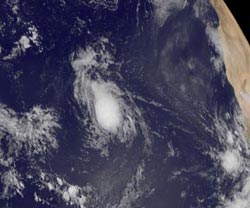
This visible image of Tropical Storm Joyce was captured by NOAA's GOES-13 satellite on Aug. 23 at 7:45 a.m. EDT. Credit: NASA GOES Project<br>
When NOAA's GOES-13 satellite captured an image of Tropical Depression 10 (TD10) on Aug. 23 at 7:45 a.m. EDT it appeared to have a well-rounded circulation. Infrared imagery indicated cold cloud top temperatures. Cold cloud top temperatures as cold as -63 Fahrenheit (-52 Celsius) show strength in the uplift of air that helps create strong thunderstorms that make up the tropical cyclone. The GOES-13 image was created using the NOAA satellite data at NASA's GOES Project, located at NASA's Goddard Space Flight Center in Greenbelt, Md.
On Aug. 23 at 11 a.m. EDT, Tropical Storm Joyce had maximum sustained winds near 40 mph (65 kmh). Joyce was located far from land, about 1,305 miles (2,105 km) east of the Leeward Islands near 15.2 North latitude and 42.2 West longitude. It was moving to the west-northwest near 17 mph (28 kmh).
Satellite data indicates that Joyce is dealing with a dry Saharan air layer, something that usually saps a tropical cyclone's warm, moist air. That dry air is wrapping around the southwestern part of Joyce's circulation.
The Saharan Air Layer is one thing that NASA is going to investigate in its upcoming Hurricane Severe Storm Sentinels (HS3) mission in September, using unmanned aircraft. For more information, go to: http://www.nasa.gov/HS3.
The National Hurricane Center noted that Joyce is following the southern edge of a subtropical ridge (elongated area) of high pressure over the Central Atlantic Ocean. Think of a marble rolling around the edge of a round clock. Once Joyce (the marble in this example) reaches the western edge, it will begin to turn to the northwest and then to the north.
Media Contact
More Information:
http://www.nasa.govAll latest news from the category: Earth Sciences
Earth Sciences (also referred to as Geosciences), which deals with basic issues surrounding our planet, plays a vital role in the area of energy and raw materials supply.
Earth Sciences comprises subjects such as geology, geography, geological informatics, paleontology, mineralogy, petrography, crystallography, geophysics, geodesy, glaciology, cartography, photogrammetry, meteorology and seismology, early-warning systems, earthquake research and polar research.


Newest articles

Superradiant atoms could push the boundaries of how precisely time can be measured
Superradiant atoms can help us measure time more precisely than ever. In a new study, researchers from the University of Copenhagen present a new method for measuring the time interval,…

Ion thermoelectric conversion devices for near room temperature
The electrode sheet of the thermoelectric device consists of ionic hydrogel, which is sandwiched between the electrodes to form, and the Prussian blue on the electrode undergoes a redox reaction…

Zap Energy achieves 37-million-degree temperatures in a compact device
New publication reports record electron temperatures for a small-scale, sheared-flow-stabilized Z-pinch fusion device. In the nine decades since humans first produced fusion reactions, only a few fusion technologies have demonstrated…

