NASA sees massive rainfall totals from Tropical Storm Oswald
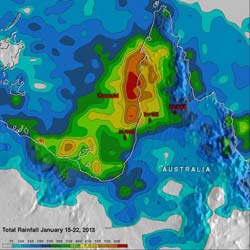
This TRMM satellite rainfall analysis covers the period from Jan. 15-22, 2013. The analysis showed that Oswald and its remnants have already dropped over 600 mm (~23.6 inches) of rain in areas of the Cape York Peninsula near the Gulf of Carpentaria.<br><br>Credit: NASA/SSAI, Hal Pierce<br>
Tropical cyclone Oswald's sustained winds have never been greater than 35 knots (~40.2 mph) but the storm's extreme rainfall has resulted in widespread flooding in Australia over northern Queensland. Many roads have been reported flooded resulting in some communities being cut off.
NASA's Tropical Rainfall Measuring Mission (TRMM) is a satellite that can measure rainfall from space. TRMM-based satellite precipitation estimates are created at NASA's Goddard Space Flight Center in Greenbelt, Md. within about seven hours of observation time. Hal Pierce of NASA Goddard created a rainfall image from a Multi-satellite Precipitation Analysis (MPA) for the period from January 15 to 22, 2013. The analysis showed that Oswald and its remnants had dropped over 600 mm (~23.6 inches) of rain in areas of the Cape York Peninsula near the Gulf of Carpentaria.
According to a report on news.com.au, travelers were requested to cancel plans to go to the Cape York Peninsula, Queensland. Many rivers have flooded and dirt roads are mired in mud over a distance of 560 kilometers (348 miles) that stretch from Laura to Bamaga. Rainfall totals over the Cape York Peninsula to Cardwell were as high as 200mm (7.8 inches) to 300 mm (11.8 inches), which fell south of the town of Innisfail.
For Oswald's storm history, visit NASA's Hurricane page: http://www.nasa.gov/mission_pages/hurricanes/archives/2013/h2013_Oswald.html
Media Contact
More Information:
http://www.nasa.govAll latest news from the category: Earth Sciences
Earth Sciences (also referred to as Geosciences), which deals with basic issues surrounding our planet, plays a vital role in the area of energy and raw materials supply.
Earth Sciences comprises subjects such as geology, geography, geological informatics, paleontology, mineralogy, petrography, crystallography, geophysics, geodesy, glaciology, cartography, photogrammetry, meteorology and seismology, early-warning systems, earthquake research and polar research.


Newest articles

High-energy-density aqueous battery based on halogen multi-electron transfer
Traditional non-aqueous lithium-ion batteries have a high energy density, but their safety is compromised due to the flammable organic electrolytes they utilize. Aqueous batteries use water as the solvent for…

First-ever combined heart pump and pig kidney transplant
…gives new hope to patient with terminal illness. Surgeons at NYU Langone Health performed the first-ever combined mechanical heart pump and gene-edited pig kidney transplant surgery in a 54-year-old woman…

Biophysics: Testing how well biomarkers work
LMU researchers have developed a method to determine how reliably target proteins can be labeled using super-resolution fluorescence microscopy. Modern microscopy techniques make it possible to examine the inner workings…

