NASA Sees Large Tropical Storm Fengshen Skirting Eastern Japan's Coastline
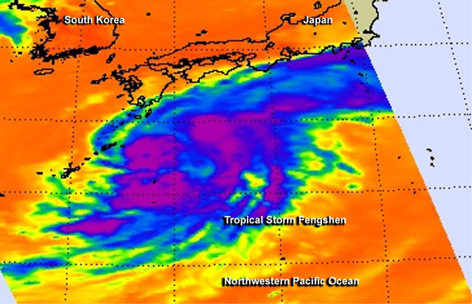
The AIRS instrument aboard NASA's Aqua satellite captured this infrared look at Tropical Storm Fengshen east of Japan on Sept. 8. Image Credit: NASA JPL, Ed Olsen
NASA's Aqua satellite passed over Tropical Storm Fengshen on September 7 and the Atmospheric Infrared Sounder instrument known as AIRS gathered temperature data about the storm's cloud tops and surrounding sea surface temperatures.
The infrared data showed strong thunderstorms surrounded the center of circulation and also appeared in large bands south and northeast of the storm's center. Another large and fragmented band on strong thunderstorms stretched to the northeast of the center of the storm and ran northeastward along Japan's east coast.
On September 8 at 1500 UTC (11 a.m. EDT), Tropical Storm Fengshen had maximum sustained winds near 55 knots (63.2 mph/102 kph). It was moving to the east-northeast at 23 knots (26.4 mph/42.6 kph) and away from the big island of Japan.
Fengshen was centered near 31.4 north latitude and 140.6 east longitude about 264 nautical miles (303 miles/488.9 km) south of Yokosuka, Japan. For a list of warnings in Japan, visit the Japan Meteorological Agency website: http://www.jma.go.jp/en/warn/.
Microwave satellite data on September 8, showed an eye with strong thunderstorms banding north of the center of circulation and wrapping into it.
That microwave data was taken from the MetOp-B satellite. MetOp is a series of three polar orbiting meteorological satellites operated by the European Organisation for the Exploitation of Meteorological Satellites (EUMETSAT).
Fengshen is expected to intensify to typhoon strength before undergoing extra-tropical transitioning as it continues to move east and away from Japan.
Rob Gutro
NASA's Goddard Space Flight Center
Media Contact
All latest news from the category: Earth Sciences
Earth Sciences (also referred to as Geosciences), which deals with basic issues surrounding our planet, plays a vital role in the area of energy and raw materials supply.
Earth Sciences comprises subjects such as geology, geography, geological informatics, paleontology, mineralogy, petrography, crystallography, geophysics, geodesy, glaciology, cartography, photogrammetry, meteorology and seismology, early-warning systems, earthquake research and polar research.


Newest articles

Properties of new materials for microchips
… can now be measured well. Reseachers of Delft University of Technology demonstrated measuring performance properties of ultrathin silicon membranes. Making ever smaller and more powerful chips requires new ultrathin…

Floating solar’s potential
… to support sustainable development by addressing climate, water, and energy goals holistically. A new study published this week in Nature Energy raises the potential for floating solar photovoltaics (FPV)…

Skyrmions move at record speeds
… a step towards the computing of the future. An international research team led by scientists from the CNRS1 has discovered that the magnetic nanobubbles2 known as skyrmions can be…

