NASA sees large Tropical Storm Banyan stretched over southern Philippines
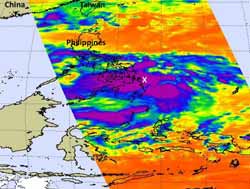
When NASA's Aqua satellite flew over Tropical Storm Banyan (Ramon) on Oct. 11, 2011, at 12:53 EDT, NASA AIRS infrared imagery showed Banyan's strong convection (purple) has strengthened and grown in area. Convection is slightly west of the center (marked with a white "X") which indicates wind shear from the east. Credit: Credit: NASA JPL, Ed Olsen<br>
Banyan strengthened overnight into a tropical storm. It was born yesterday, Oct. 10, 2011 as Tropical Depression 23W. The Philippines have also given Banyan a name, and call it Ramon.
At 10 a.m. EDT on Oct. 11, Banyan's (Ramon) maximum sustained winds are near 35 knots (40 mph/65 kmh), and Banyan is moving to the west-northwest near 14 knots (16 km/26 kmh). Banyan's center may 485 miles southeast of Manila, Philippines near 9.2 North and 126.4 East, but clouds already cover the southern Philippines.
When NASA's Aqua satellite flew over Tropical Storm Banyan today, Oct. 11, 2011 at 12:53 EDT (4:53 UTC), the Atmospheric Infrared Sounder (AIRS) instrument measured temperatures in and around the storm. AIRS infrared imagery showed Banyan's convection (rising air that forms thunderstorms that make up the tropical storm) has strengthened and grown in area. Cloud top temperatures exceed the -63F (-52C) threshold for strong convection, mostly in the eastern and western quadrants of the storm. Infrared data also shows that the convection is slightly off-center – west of the center, which indicates wind shear from the east.
Warnings are in effect for a number of areas as heavy rainfall and gusty winds are possible. Public storm warning signal #2 is in effect in the Mindanao provinces of Surigao del Norte and Sur, Siargao Island and Dinagat Island.
Signal #1 is in effect for the Visayas provinces of Southern Leyte and Eastern Samar, and in the Mindanao provinces of Agusan Del Norte and Sur, Misamis Oriental and Camiguin Island; the Visayas provinces of Northern Leyte, Biliran Island, Bohol, Cebu, Northern Negros, Northern & Western Samar, Panay Island and Guimaras Island; and the Luzon provinces of Masbate, Ticao Island, Romblon and Sorsogon.
The Joint Typhoon Warning Center forecasts a landfall by Tropical Storm Banyan by 11 p.m. EDT tonight (Oct. 12 at 0300 UTC) over northeastern Mindanao. It is expected to weaken over the Visayan Islands and move into the South China Sea, where warm waters are expected to re-strengthen it.
Media Contact
More Information:
http://www.nasa.govAll latest news from the category: Earth Sciences
Earth Sciences (also referred to as Geosciences), which deals with basic issues surrounding our planet, plays a vital role in the area of energy and raw materials supply.
Earth Sciences comprises subjects such as geology, geography, geological informatics, paleontology, mineralogy, petrography, crystallography, geophysics, geodesy, glaciology, cartography, photogrammetry, meteorology and seismology, early-warning systems, earthquake research and polar research.


Newest articles

Silicon Carbide Innovation Alliance to drive industrial-scale semiconductor work
Known for its ability to withstand extreme environments and high voltages, silicon carbide (SiC) is a semiconducting material made up of silicon and carbon atoms arranged into crystals that is…

New SPECT/CT technique shows impressive biomarker identification
…offers increased access for prostate cancer patients. A novel SPECT/CT acquisition method can accurately detect radiopharmaceutical biodistribution in a convenient manner for prostate cancer patients, opening the door for more…

How 3D printers can give robots a soft touch
Soft skin coverings and touch sensors have emerged as a promising feature for robots that are both safer and more intuitive for human interaction, but they are expensive and difficult…

