NASA Sees Katia Become Second Atlantic Hurricane
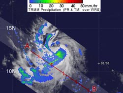
TRMM captured a rainfall image of Tropical Storm Katia on August, 31, 2011 2:29 p.m. EDT. Yellow and green indicate rainfall between 20 and 40 millimeters (.78 to 1.57 inches) per hour. Dark red areas are considered heavy rainfall, as much as 50 mm (2 inches) of rain per hour. Credit: SSAI/NASA, Hal Pierce<br>
NASA's TRMM satellite noticed towering thunderstorms within Katia yesterday which clued forecasters that she would become a hurricane today. NASA's Aqua satellite showed strong thunderstorms around Katia's center today as the hurricane continues to strengthen.
The Tropical Rainfall Measuring Mission (TRMM) satellite can measure rainfall from its orbit high above the earth and provide heights of towering thunderstorms within a tropical cyclone. Yesterday, August 31, 2011 at 2:29 p.m. EDT (18:29 UTC) TRMM revealed several towering thunderstorms even in Katia's outer bands- that were about 6 miles (10 kilometers) high.
On September 1, the Atmospheric Infrared Sounder (AIRS) instrument on NASA's Aqua satellite showed large areas of strong convection surrounding center. Convection is rapidly rising air that forms the thunderstorms that make up a tropical cyclone. The cloud top temperatures around Katia's center were colder than -63F (-52C) revealing that there's powerful uplift in the atmosphere to create high, cold clouds. AIRS also showed that the sea surface temperatures in the region are over the 80F (26.6C) threshold needed to maintain a tropical cyclone, so that the energy source for Katia remains plentiful and will enable her to strengthen over the weekend.
Katia is a now a Category one hurricane and is expected to bend north-northwest and miss the Leeward Islands. Maximum sustained winds are near 75 mph (120 kmh) with higher gusts, and some strengthening is forecast over the weekend. Katia is still a small storm about 250 miles wide, with hurricane force winds out to 25 miles from the center (35 km) and tropical storm force winds out to 125 miles (205 km).
The National Hurricane Center noted that Katia could become a major hurricane (Category three) over the weekend.
At 11 a.m. EDT on Sept. 1, Katia's center was still far from land. It was about 1050 miles (1,685 km) east of the Leeward Islands, near 15.5 North and 47.5 West. It was moving to the west-northwest near 18 mph (30 kmh) and is expected to slow down.
The National Hurricane Center said Katia is forecast to become a major hurricane on Sunday with winds over 111 mph. It will be between Puerto Rico and Bermuda so NASA will be watching it for the next week.
Text credit: Rob Gutro, NASA's Goddard Space Flight Center, Greenbelt, Md.
Media Contact
All latest news from the category: Earth Sciences
Earth Sciences (also referred to as Geosciences), which deals with basic issues surrounding our planet, plays a vital role in the area of energy and raw materials supply.
Earth Sciences comprises subjects such as geology, geography, geological informatics, paleontology, mineralogy, petrography, crystallography, geophysics, geodesy, glaciology, cartography, photogrammetry, meteorology and seismology, early-warning systems, earthquake research and polar research.


Newest articles

Combatting disruptive ‘noise’ in quantum communication
In a significant milestone for quantum communication technology, an experiment has demonstrated how networks can be leveraged to combat disruptive ‘noise’ in quantum communications. The international effort led by researchers…

Stretchable quantum dot display
Intrinsically stretchable quantum dot-based light-emitting diodes achieved record-breaking performance. A team of South Korean scientists led by Professor KIM Dae-Hyeong of the Center for Nanoparticle Research within the Institute for…

Internet can achieve quantum speed with light saved as sound
Researchers at the University of Copenhagen’s Niels Bohr Institute have developed a new way to create quantum memory: A small drum can store data sent with light in its sonic…

