NASA sees heavy rains in Tropical Storm Bingiza, possibly headed for second landfall
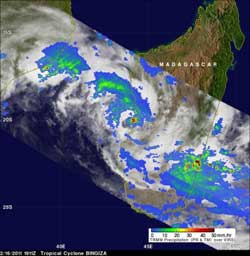
NASA\'s TRMM satellite saw moderate to heavy rainfall, falling at a rate of over 2 inches/50 mm per hour (in red) in a small area near Bingiza\'s center of circulation on Feb. 16, 2011. Credit: SSAI/NASA, Hal Pierce<br>
Deadly Tropical Cyclone Bingiza, which crossed over northern Madagascar three days ago, has continued to affect Madagascar while moving along Madagascar's west coast. Bingiza had weakened from a powerful category 3 tropical cyclone with sustained winds of 100 kts (~115 mph/185 kmh) to tropical storm force winds of about 35 kts (~40 mph/65 kmh) when the Tropical Rainfall Measuring Mission (TRMM) satellite passed almost directly overhead on February 16, 2011 at 1911 UTC (2:11 p.m. EST).
TRMM data was used to create an image of Bingiza's rainfall. The analysis used TRMM's Microwave Imager (TMI) and Precipitation Radar (PR) data. At that time, Bingiza was approaching Madagascar from the Mozambique Channel with additional moderate to heavy rainfall (over 2 inches/50 mm per hour). Extremely heavy rainfall was revealed to be located in a small area near Bingiza's center of circulation.
On February 17 at 0900 UTC (4 a.m. EST), Bingiza's maximum sustained winds were near 40 knots (46 mph/74 kmh) with higher gusts. It was about 220 nautical miles west-southwest of Antananarivo, Madagascar, near 21.0 South and 43.7 East. Bingiza was moving south at 7 knots (8 mph/13 kmh).
Multispectral satellite imagery showed that Bingiza still has strong bands of thunderstorms wrapping around it from the northwest into the southeast quadrant. The low-level center of circulation is partially exposed to outside winds, however. Exposure to outside winds leaves the storm vulnerable for weakening.
A low to mid-level ridge (elongated area of high pressure) located to the northeast of Bingiza is what's guiding it southward, and then it is forecast to track along the ridge and move southeastward in the next day taking it near or over land. Some models show that the storm may meander and remain over water while others take it inland. Whether it stays near the coast or moves inland, Bingiza is still forecast to weaken and is expected to dissipate by the weekend.
Media Contact
More Information:
http://www.nasa.govAll latest news from the category: Earth Sciences
Earth Sciences (also referred to as Geosciences), which deals with basic issues surrounding our planet, plays a vital role in the area of energy and raw materials supply.
Earth Sciences comprises subjects such as geology, geography, geological informatics, paleontology, mineralogy, petrography, crystallography, geophysics, geodesy, glaciology, cartography, photogrammetry, meteorology and seismology, early-warning systems, earthquake research and polar research.


Newest articles

Silicon Carbide Innovation Alliance to drive industrial-scale semiconductor work
Known for its ability to withstand extreme environments and high voltages, silicon carbide (SiC) is a semiconducting material made up of silicon and carbon atoms arranged into crystals that is…

New SPECT/CT technique shows impressive biomarker identification
…offers increased access for prostate cancer patients. A novel SPECT/CT acquisition method can accurately detect radiopharmaceutical biodistribution in a convenient manner for prostate cancer patients, opening the door for more…

How 3D printers can give robots a soft touch
Soft skin coverings and touch sensors have emerged as a promising feature for robots that are both safer and more intuitive for human interaction, but they are expensive and difficult…

