NASA sees Gonzalo affect Bermuda's ocean sediment: Stirred, not shaken
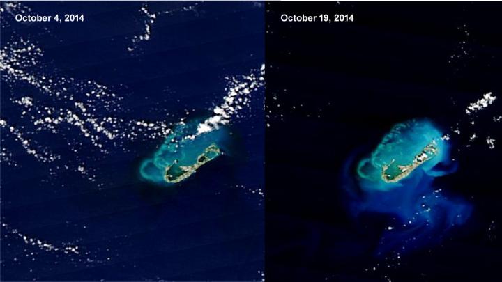
This is comparison of NASA satellite imagery before (Oct. 4) and after (Oct. 19) Hurricane Gonzalo passed shows the sediment stirred up (green, blue). Credit: NASA Goddard MODIS Rapid Response Team
The MODIS instrument or Moderate Resolution Imaging Spectroradiometer that flies aboard NASA's Aqua and Terra satellites provided imagery of Bermuda and the stirred sediment.
In a comparison of imagery before and after Hurricane Gonzalo passed, the after image showed sediment streaming east and south of Bermuda.
The MODIS instrument aboard NASA's Aqua satellite captured a “before” look of Bermuda on Oct. 4 at 17:20 UTC (1:20 p.m. EDT). The MODIS instrument aboard NASA's Terra satellite captured the “after” image from Oct. 19 at 15:00 UTC (11 a.m. EDT).
Whenever a hurricane moves over an area, it stirs up sediment from the ocean bottom. In more shallow areas the mixing of sediment to the surface is more visible on satellite imagery.
Around Bermuda, the ocean is shallow. There are coral reefs and banks that can be seen under the surface when waters are clear. Bermuda's coral reefs are some of the northern-most reefs in the North Atlantic.
In the MODIS images a lighter blue area traces the outline of the shallow waters around the reef. The deeper water around it appears dark blue.
Run off of sand dirt from the island fans out in tan and light green plumes. The extra nutrients that the run-off and bottom sediment bring to the surface may be feeding surface-dwelling ocean plants, which may also color ocean waters turquoise.
As the sediment settles around Bermuda, the United Kingdom was dealing with post-tropical cyclone Gonzalo's remnants.
Gonzalo's remnants were bringing heavy rains and gusty winds to much of the United Kingdom on Tuesday, Oct. 21. The U.K. Meteorological Service forecast wind gusts between 40 and 50 mph. In some coastal areas, winds could reach 60 to 70 mph. For updated forecasts from the U.K. Met Service, visit: http://www.metoffice.gov.uk.
Media Contact
More Information:
http://www.nasa.govAll latest news from the category: Earth Sciences
Earth Sciences (also referred to as Geosciences), which deals with basic issues surrounding our planet, plays a vital role in the area of energy and raw materials supply.
Earth Sciences comprises subjects such as geology, geography, geological informatics, paleontology, mineralogy, petrography, crystallography, geophysics, geodesy, glaciology, cartography, photogrammetry, meteorology and seismology, early-warning systems, earthquake research and polar research.


Newest articles

Machine learning algorithm reveals long-theorized glass phase in crystal
Scientists have found evidence of an elusive, glassy phase of matter that emerges when a crystal’s perfect internal pattern is disrupted. X-ray technology and machine learning converge to shed light…

Mapping plant functional diversity from space
HKU ecologists revolutionize ecosystem monitoring with novel field-satellite integration. An international team of researchers, led by Professor Jin WU from the School of Biological Sciences at The University of Hong…

Inverters with constant full load capability
…enable an increase in the performance of electric drives. Overheating components significantly limit the performance of drivetrains in electric vehicles. Inverters in particular are subject to a high thermal load,…

