NASA Sees Emilia as a Category 2 Hurricane Now
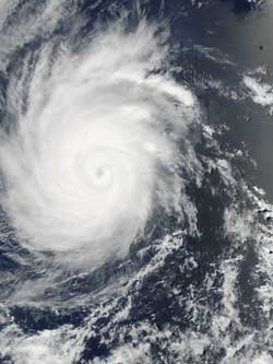
NASA's Aqua satellite captured this visible image of Hurricane Emilia on July 10, 2012 at 2035 UTC / 4:35 p.m. EDT. Credit: NASA MODIS Rapid Response Team <br>
The Moderate Resolution Imaging Spectroradiometer (MODIS) instrument that flies onboard NASA's Aqua satellite captured a visible image of Hurricane Emilia on July 10, 2012 at 2035 UTC / 4:35 p.m. EDT when its winds had weakened down to 125 mph (205 kmh). Emilia continued weakening after Aqua passed by.
On July 11 at 5 a.m. EDT, Emilia's maximum sustained winds were near 105 mph (165 kmh) and is now a Category 2 hurricane on the Saffir-Simpson scale. Emilia is over 210 miles (330 km) in diameter, which is the extent of its tropical-storm-force winds. On July 11 the Atmospheric Infrared Sounder (AIRS) data from NASA's Aqua satellite showed that cloud top temperatures around Emilia's eye were still as cold as -94 Fahrenheit (-70 Celsius) indicating the eye is still surrounded by powerful thunderstorms.
Emilia was located about 720 miles (1160 km) southwest of the southern tip of Baja California. Emilia is moving at 10 mph (17 kmh) to the west-northwest. Emilia is expected to continue moving in the same direction because it is skirting the southern edge of a subtropical ridge (elongated area) of high pressure (which rotates clockwise), located to its north.
The National Hurricane Center expects Emilia to continue on a weakening trend as it moves over cooler waters and runs into drier and more stable air as wind shear increases.
For larger image, visit: http://lance-modis.eosdis.nasa.gov/cgi-bin/imagery/single.cgi?image=Emilia.A2012192.2035.250m.jpg.
Text Credit: Rob Gutro
NASA's Goddard Space Flight CenterGreenbelt, Md.
Media Contact
All latest news from the category: Earth Sciences
Earth Sciences (also referred to as Geosciences), which deals with basic issues surrounding our planet, plays a vital role in the area of energy and raw materials supply.
Earth Sciences comprises subjects such as geology, geography, geological informatics, paleontology, mineralogy, petrography, crystallography, geophysics, geodesy, glaciology, cartography, photogrammetry, meteorology and seismology, early-warning systems, earthquake research and polar research.


Newest articles

Silicon Carbide Innovation Alliance to drive industrial-scale semiconductor work
Known for its ability to withstand extreme environments and high voltages, silicon carbide (SiC) is a semiconducting material made up of silicon and carbon atoms arranged into crystals that is…

New SPECT/CT technique shows impressive biomarker identification
…offers increased access for prostate cancer patients. A novel SPECT/CT acquisition method can accurately detect radiopharmaceutical biodistribution in a convenient manner for prostate cancer patients, opening the door for more…

How 3D printers can give robots a soft touch
Soft skin coverings and touch sensors have emerged as a promising feature for robots that are both safer and more intuitive for human interaction, but they are expensive and difficult…

