NASA sees deadly Cyclone Giovanna over the center of Madagascar
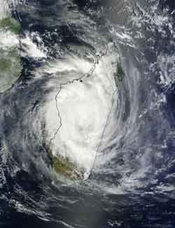
On Feb. 14, 2012, at 07:15 UTC (10:15 a.m. local time -- Madagascar/3:15 a.m. EST), the MODIS instrument on NASA's Terra Satellite captured this visible image of Cyclone Giovanna almost directly in the center of the island of Madagascar. Credit: NASA Goddard MODIS Rapid Response Team<br>
NASA's Aqua satellite captured an image when Giovanna's center was close to the capital city of Antananarivo, and NASA's TRMM satellite saw powerful towering thunderstorms around its center before it made landfall.
According to BBC News, Giovanna made landfall near the eastern port city of Toamasina with winds gusting to 120 mph (194km). Giovanna brought heavy rain, and its strong winds flattened trees. Storm surges continue to pound coastal areas as Giovanna tracks over the fourth-largest island in the world. Rainfall totals are expected between 10 and 20 inches (250 to 500 mm), and may trigger landslides in higher elevations.
On February 14, 2012 at 07:15 UTC (10:15 a.m. local time – Madagascar/3:15 a.m. EST), the Moderate Resolution Imaging Spectroradiometer (MODIS) instrument on NASA's Terra Satellite captured a visible image of Cyclone Giovanna almost directly in the center of the island of Madagascar. Giovanna had weakened as a result of its interaction with land, and its eye had “closed.”
Five hours later on Feb. 14, around 1200 UTC (7 a.m. EST), Giovanna was still tracking over land and weakened significantly to a minimal tropical storm. Maximum sustained winds were near 35 knots (40.2 mph/65 kph) and it was located about 100 nautical miles west of Antananarivo, Madagascar, near 19.6 South and 44.7 East. Giovanna is moving west at 14 knots (16.1 mph/26 kph).
The capitol city of Antananarivo reported a maximum wind speed of 32 knots (10-minute average) (~37 mph/~59 kph) with higher gusts.
As Giovanna approached Madagascar on February 13, another NASA satellite called the Tropical Rainfall Measuring Mission satellite (TRMM) had a fairly good early morning view if it. At 0333 UTC on Feb. 13, rainfall rates were obtained from TRMM Microwave Imager (TMI) and were overlaid on a visible/infrared image from TRMM's Visible and InfraRed Scanner (VIRS) instrument at NASA's Goddard Space Flight Center in Greenbelt, Md. At that time, Giovanna was an intensifying category 4 tropical cyclone with wind speeds estimated at over 125 knots (~144 mph).
Tropical cyclone Giovanna was located in the Indian Ocean east-northeast of Madagascar when it was classified as a tropical storm on February 9, 2012. When the TRMM satellite flew over Giovanna on February 11 at 1200 UTC, it was rapidly becoming more powerful. On the 11th, Giovanna had intensified to a category 3 tropical cyclone on the Saffir-Simpson scale with wind speeds estimated at 100 knots (~115 mph). That TRMM pass showed that an eyewall replacement was occurring at that time. A small ring of strong convective storms was located around the center of the center eye and other powerful storms were seen in the replacement eye further out from Giovanna's center.
The data from the TRMM Precipitation Radar (PR) data were also used to create a 3-D image of the storm. This image, looking from east, shows the structure of Giovanna's double eye wall. TRMM PR data shows that the tallest storm towers reaching to heights of almost 15km (~9.3 miles) were on Giovanna's eastern side. The storm towers in Giovanna's center were reaching to about 11km (~6.8 miles).
Giovanna is now expected to move into the Mozambique Channel where the warm waters will allow it to quickly reorganize. Forecast models take the storm to the center of the channel and then curve it back to the southeast over the next couple of days.
Media Contact
More Information:
http://www.nasa.govAll latest news from the category: Earth Sciences
Earth Sciences (also referred to as Geosciences), which deals with basic issues surrounding our planet, plays a vital role in the area of energy and raw materials supply.
Earth Sciences comprises subjects such as geology, geography, geological informatics, paleontology, mineralogy, petrography, crystallography, geophysics, geodesy, glaciology, cartography, photogrammetry, meteorology and seismology, early-warning systems, earthquake research and polar research.


Newest articles

Eruption of mega-magnetic star lights up nearby galaxy
Thanks to ESA satellites, an international team including UNIGE researchers has detected a giant eruption coming from a magnetar, an extremely magnetic neutron star. While ESA’s satellite INTEGRAL was observing…

Solving the riddle of the sphingolipids in coronary artery disease
Weill Cornell Medicine investigators have uncovered a way to unleash in blood vessels the protective effects of a type of fat-related molecule known as a sphingolipid, suggesting a promising new…
Rocks with the oldest evidence yet of Earth’s magnetic field
The 3.7 billion-year-old rocks may extend the magnetic field’s age by 200 million years. Geologists at MIT and Oxford University have uncovered ancient rocks in Greenland that bear the oldest…

