NASA sees Cyclone Zane bearing down on Queensland, Australia
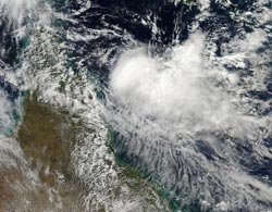
NASA's Aqua satellite captured an image of Cyclone Zane headed toward the northern Cape York Peninsula of Queensland where it is expected to make landfall by May 2 and cross into the Gulf of Carpentaria.<br><br>Credit: Rob Gutro, NASA's Goddard Space Flight Center<br>
A cyclone Warning is in effect for coastal areas from Mapoon to Cape York to Cape Flattery.
NASA's Aqua satellite passed over Zane on May 1 at 04:05 UTC (12:05 a.m. EDT) and the Moderate Resolution Imaging Spectroradiometer instrument captured a visible image of the cyclone. Zane's most powerful thunderstorms continue to be around the low-level circulation center, and south of the center.
At 0900 UTC (5 a.m. EDT), Cyclone Zane's maximum sustained winds were near 55 knots (63.2 mph/101.9 kph). Zane is tropical storm strength. Zane was moving to the west at 7 knots (8 mph/12.9 kph), and was located near 13.8 south latitude and 146.8 east longitude, about 190 nautical miles (218.6 miles/351.9 km) north-northeast of Cairns, Australia.
At 1200 UTC (8 a.m. EDT) Tropical Cyclone Zane was near 13.2 south and 145.5 east, moving to the west-northwest near 10 knots (11.5 mph/18.5 kph) about 115 nautical miles (132.3 miles/213 km) east of Lockhart River and 110 nautical miles (126.6 miles/203.7 km) north of Cape Flattery. Zane's maximum sustained winds had dropped to 45 knots (51.7 mph/83.3 kph) over the course of three hours.
Animated multispectral satellite imagery showed that the low level circulation center is partially exposed to outside winds. Vertical wind shear has been increasing from the northwest, and the forecasters at the Joint Typhoon Warning Center now expect Zane to weaken before making landfall in northeastern Queensland. After a brief track west across the Cape York Peninsula, Zane is expected to emerge into the Gulf of Carpentaria where wind shear will weaken and dissipate the storm.
Media Contact
More Information:
http://www.nasa.govAll latest news from the category: Earth Sciences
Earth Sciences (also referred to as Geosciences), which deals with basic issues surrounding our planet, plays a vital role in the area of energy and raw materials supply.
Earth Sciences comprises subjects such as geology, geography, geological informatics, paleontology, mineralogy, petrography, crystallography, geophysics, geodesy, glaciology, cartography, photogrammetry, meteorology and seismology, early-warning systems, earthquake research and polar research.


Newest articles

Bringing bio-inspired robots to life
Nebraska researcher Eric Markvicka gets NSF CAREER Award to pursue manufacture of novel materials for soft robotics and stretchable electronics. Engineers are increasingly eager to develop robots that mimic the…

Bella moths use poison to attract mates
Scientists are closer to finding out how. Pyrrolizidine alkaloids are as bitter and toxic as they are hard to pronounce. They’re produced by several different types of plants and are…

AI tool creates ‘synthetic’ images of cells
…for enhanced microscopy analysis. Observing individual cells through microscopes can reveal a range of important cell biological phenomena that frequently play a role in human diseases, but the process of…

