NASA Sees Cyclone Jasmine's Power and New Eye
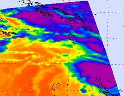
This infrared image was taken from the AIRS instrument on NASA's Aqua satellite, on February 7, 2012 at 03:17 UTC. Jasmine's strongest thunderstorms are close to the center of circulation and in bands of thunderstorms to the north and east of center, (purple) where cloud top temperatures are below -63 F (-52.7C).<br>Credit: NASA/JPL, Ed Olsen <br>
NASA's Aqua satellite passed overhead early on February 7 and noticed the strongest part of the cyclone was around the center and north and east of the center, and noticed that an eye has developed.
The Atmospheric Infrared Sounder (AIRS) instrument on NASA's Aqua satellite captured an infrared image of Jasmine on February 7, 2012 at 03:17 UTC (2:17 p.m., Pacific/Noumea local time/Feb 6, 10:17 p.m. EST). Jasmine's strongest thunderstorms were close to the center of circulation and in bands of thunderstorms to the north and east of center, where cloud top temperatures are below -63 F (-52.7C). Those were the areas experiencing the heaviest rainfall. Satellite data also revealed a ragged-looking eye about 24 nautical miles (27.6 miles/44.5 km) in diameter.
On February 7, a Yellow Alert remains current for Malampa, Shefa and Tafea Provinces of Vanuatu. The New Caledonia warnings included an orange alert for the Loyalty Islands, and the rest of the territory is on yellow pre-alert.
On February 7 at 0900 UTC, Jasmine has maximum sustained winds near 100 knots (115 mph/185 kph). It was located about 220 nautical miles (253.2 miles/407.4 km) north-northwest of Noumea, New Caledonia near 18.9 South and 165.2 East. Jasmine was moving to the southeast at 16 knots (18.4 mph/29.6 kph).
Jasmine continues to gain strength as it zig-zags slightly to the east-southeast and is expected to weaken later in the week.
Text Credit: Rob Gutro
NASA's Goddard Space Flight Center, Greenbelt, Md.
Media Contact
All latest news from the category: Earth Sciences
Earth Sciences (also referred to as Geosciences), which deals with basic issues surrounding our planet, plays a vital role in the area of energy and raw materials supply.
Earth Sciences comprises subjects such as geology, geography, geological informatics, paleontology, mineralogy, petrography, crystallography, geophysics, geodesy, glaciology, cartography, photogrammetry, meteorology and seismology, early-warning systems, earthquake research and polar research.


Newest articles

Superradiant atoms could push the boundaries of how precisely time can be measured
Superradiant atoms can help us measure time more precisely than ever. In a new study, researchers from the University of Copenhagen present a new method for measuring the time interval,…

Ion thermoelectric conversion devices for near room temperature
The electrode sheet of the thermoelectric device consists of ionic hydrogel, which is sandwiched between the electrodes to form, and the Prussian blue on the electrode undergoes a redox reaction…

Zap Energy achieves 37-million-degree temperatures in a compact device
New publication reports record electron temperatures for a small-scale, sheared-flow-stabilized Z-pinch fusion device. In the nine decades since humans first produced fusion reactions, only a few fusion technologies have demonstrated…

