NASA sees Cyclone Giovanna enter the Mozambique Channel
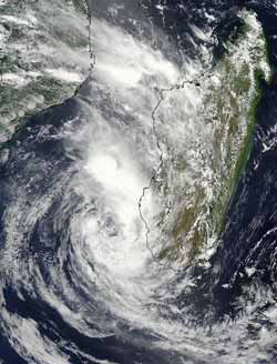
MODIS captured a visible image of Cyclone Giovanna in the Mozambique Channel at 10:45 UTC (5:45 a.m. EST) on Feb. 15, 2012. The image showed the convection had diminished greatly in the northwestern quadrant of the storm. Credit: NASA Goddard MODIS Rapid Response Team<br>
Once Giovanna traversed the island nation of Madagascar and entered the Mozambique Channel, the body of water between Madagascar and Mozambique on the African mainland, NASA's Aqua satellite passed overhead and captured a visible image with the Moderate Resolution Imaging Spectroradiometer (MODIS) instrument.
MODIS captured the image at 10:45 UTC (5:45 a.m. EST) on February 15. The image showed that convection (rising air that forms the thunderstorms that make up the storm) had diminished greatly in the northwestern quadrant of the storm,. The MODIS image also showed that thunderstorms were now building around the rest of the tropical storm as a result ove moving into the warm waters of the Mozambique Channel. Sea surface temperatures of at least 80 Fahrenheit (26.6 Celsius) are needed to maintain a tropical cyclone, and temperatures in the Channel are as warm as ~88 Fahrenheit (31 Celsius).
On February 15, 2012 at 0300 UTC (Feb. 14 at 10 p.m. EST), Tropical Storm Giovanna's maximum sustained winds were near 40 knots (46 mph/74 kph). Tropical Cyclone Giovanna's center was located approximately 250 nautical miles west-southwest of Antananarivo, Madagascar, near 20.8 South and 42.4 East. It is moving to the west-southwest at 13 knots (15 mph/24 kph).
BBC News reports that at least two people died from storm related incidents, and the town Vatomandry, south of where Giovanna made landfall in east-central Madagascar, has experienced a lot of damage. BBC News reports that at least 60 percent of homes in the town were damaged or destroyed. Trees, phone and power lines have been downed, especially in eastern areas, as recovery efforts continue.
The Joint Typhoon Warning Center uses satellite data and forecast computer models to create forecasts. The current forecast for Giovanna now takes it on a westerly track toward Mozambique by the week's end. The forecast also indicates that wind shear will increase, which will prevent the storm from strengthening further. Residents along the southeastern coast of Mozambique should monitor the path of this tropical storm.
Media Contact
More Information:
http://www.nasa.govAll latest news from the category: Earth Sciences
Earth Sciences (also referred to as Geosciences), which deals with basic issues surrounding our planet, plays a vital role in the area of energy and raw materials supply.
Earth Sciences comprises subjects such as geology, geography, geological informatics, paleontology, mineralogy, petrography, crystallography, geophysics, geodesy, glaciology, cartography, photogrammetry, meteorology and seismology, early-warning systems, earthquake research and polar research.


Newest articles

Superradiant atoms could push the boundaries of how precisely time can be measured
Superradiant atoms can help us measure time more precisely than ever. In a new study, researchers from the University of Copenhagen present a new method for measuring the time interval,…

Ion thermoelectric conversion devices for near room temperature
The electrode sheet of the thermoelectric device consists of ionic hydrogel, which is sandwiched between the electrodes to form, and the Prussian blue on the electrode undergoes a redox reaction…

Zap Energy achieves 37-million-degree temperatures in a compact device
New publication reports record electron temperatures for a small-scale, sheared-flow-stabilized Z-pinch fusion device. In the nine decades since humans first produced fusion reactions, only a few fusion technologies have demonstrated…

