NASA sees 2 tropical cyclones in Eastern Pacific
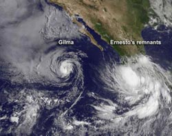
NOAA's GOES-15 satellite captured an image of Tropical Storm Gilma (left) in the eastern Pacific Ocean, with the remnant low pressure area, formerly Tropical Storm Ernesto (right), about to move into the Pacific.<br><br>Credit: NASA GOES Project<br>
On August 10, NOAA's GOES-15 satellite captured Tropical Storm Gilma and a low pressure area that was once the Atlantic Basin's Tropical storm Ernesto, now moving off the western Mexican coast.
NASA's GOES Project, located at NASA Goddard Space Flight Center in Greenbelt, Md. has been busy creating images and animations of Tropical Storm Gilma and the remnants of Tropical Storm Ernesto as it crosses Mexico from the Gulf of Mexico and has begun its entrance into the Eastern Pacific Ocean.
NASA's GOES Project uses data from NOAA's Geostationary Operational Environmental Satellites (GOES), and the GOES-15 satellite covers the Eastern Pacific Ocean basin and the eastern U.S. from a fixed orbit. GOES-15 provides continuous data that NASA makes into images and animations. An image captured on August 10, 2012 at 1500 UTC (11:00 a.m. EDT) shows Ernesto's clouds lingering over the western coast of Mexico and Gilma out over open waters.
At 11 a.m. EDT on August 10, Tropical Storm Gilma's maximum sustained winds were near 65 mph (100 kmh). The National Hurricane Center (NHC) expects Gilma to weaken over the next two days because of an increase in vertical wind shear and movement into cooler waters. The National Hurricane Center expects Gilma to become a tropical depression sometime on August 11. Gilma was centered about 670 miles (1,080 km) west-southwest of the southern tip of Baja California near latitude 18.8 north and longitude 119.3 west. Gilma is moving toward the north-northwest near 5 mph (7 kmh) and is motion is expected to continue over the next day or so.
Behind Gilma, and located along the southern coast of Mexico is a large area of showers and thunderstorms associated with the broad circulation of weakening tropical depression Ernesto. Because environmental conditions are favorable, the low, formerly known as Ernesto, has a 60 percent chance of developing into a tropical depression is it moves westward and into the open waters of the Eastern Pacific Ocean. Once it becomes a tropical depression and if it strengthens to a tropical storm, it would get a new name.
Media Contact
More Information:
http://www.nasa.govAll latest news from the category: Earth Sciences
Earth Sciences (also referred to as Geosciences), which deals with basic issues surrounding our planet, plays a vital role in the area of energy and raw materials supply.
Earth Sciences comprises subjects such as geology, geography, geological informatics, paleontology, mineralogy, petrography, crystallography, geophysics, geodesy, glaciology, cartography, photogrammetry, meteorology and seismology, early-warning systems, earthquake research and polar research.


Newest articles

Superradiant atoms could push the boundaries of how precisely time can be measured
Superradiant atoms can help us measure time more precisely than ever. In a new study, researchers from the University of Copenhagen present a new method for measuring the time interval,…

Ion thermoelectric conversion devices for near room temperature
The electrode sheet of the thermoelectric device consists of ionic hydrogel, which is sandwiched between the electrodes to form, and the Prussian blue on the electrode undergoes a redox reaction…

Zap Energy achieves 37-million-degree temperatures in a compact device
New publication reports record electron temperatures for a small-scale, sheared-flow-stabilized Z-pinch fusion device. In the nine decades since humans first produced fusion reactions, only a few fusion technologies have demonstrated…

