NASA satellites see Tropical Storm Matthew grow quickly, warnings up in Central America
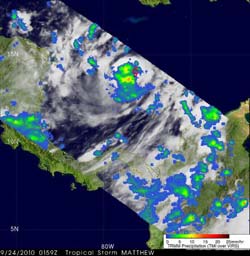
TRMM data from Sept. 24 at 0159 UTC showed moderate to heavy rainfall (red) southwest of Matthew\'s center of circulation. The approximate center of circulation is shown by a red tropical storm symbol. Credit: NASA/SSAI, Hal Pierce<br>
Cloud top temperatures indicate the strength of the storm to forecasters. The colder the cloud top temperatures, the stronger the convection and uplift. When cloud top temperatures drop, as they did in Atmospheric Infrared Sounder (AIRS) imagery captured on Sept. 23 at18:53 UTC (2:53 p.m. EDT) it indicates the storm is gaining strength.
At that time, Matthew's maximum sustained winds were near 40 mph. In the image, the coldest cloud top temperatures (colder than -63 Fahrenheit) appeared around the center of Matthew's circulation already giving the appearance of an eye. The AIRS infrared image on Sept. 24 at 3:05 a.m. EDT showed a concentrated area of strong thunderstorms around Matthew's center as the sustained winds had increased to 50 mph.
AIRS has the ability to determine cloud top and sea surface temperatures from its position in space aboard NASA's Aqua satellite. Cloud top temperatures help forecasters know if a storm is powering up or powering down and Matthew is powering up.
In addition to the Aqua satellite, the Tropical Rainfall Measuring Mission (TRMM) satellite flew nearly above Matthews's location on Sep. 24 at 0159 UTC (9:59 p.m. EDT Sept. 23) capturing data used in a rainfall analysis done at NASA's Goddard Space Flight Center in Greenbelt, Md. TRMM Microwave Imager (TMI) data analyzed from this orbit showed moderate to heavy rainfall southwest of MATTHEW's center of circulation.
At 11 a.m. EDT on Sept. 24, Matthew's maximum sustained winds were near 50 mph, and strengthening is expected in the warm Caribbean waters, so the National Hurricane Center said that Matthew could become a hurricane by Saturday. Meanwhile at 11 a.m. Sept. 24, Matthew was located about 80 miles east of Cabo Gracias a Dios, Nicaragua, near 14.4 North and 82.2 West. It was moving west at 20 mph, and had a minimum central pressure of 1001 millibars. Just 15 hours before, its minimum central pressure was 1005 millibars, and a drop in pressure indicates a strengthening storm.
A hurricane watch is in effect for Puerto Cabezas, Nicaragua to Limon, Honduras including the offshore islands. A tropical storm warning is in effect for Puerto Cabezas, Nicaragua to Limon, Honduras including the offshore islands.
A tropical storm warning is in effect for Puerto Cabezas, Nicaragua northward to the border with Honduras including the offshore islands and the coast of Honduras including the offshore islands. A tropical storm watch is in effect for the coast of Belize, while a hurricane watch is in effect for Puerto Cabezas, Nicaragua to Limon, Honduras. Hurricane conditions are possible between 11 p.m. EDT tonight and 11 a.m. EDT Saturday in that watch area.
Tropical storm-force winds are expected to reach the coastal warning areas during the afternoon of Sept. 24, and a storm surge is expected to produce flooding and dangerous surf. Expected rainfall amounts of 6 to 10 inches are forecast with isolated amounts to 15 inches.
According to the National Hurricane Center in Miami, on the forecast track the center of the Matthew is expected to be near the Nicaragua/Honduras border late Friday or early Saturday morning then move over land in northern Honduras on Saturday. Updates on Matthew can be found at the National Hurricane Center's web page: www.nhc.noaa.gov.
Media Contact
More Information:
http://www.nasa.govAll latest news from the category: Earth Sciences
Earth Sciences (also referred to as Geosciences), which deals with basic issues surrounding our planet, plays a vital role in the area of energy and raw materials supply.
Earth Sciences comprises subjects such as geology, geography, geological informatics, paleontology, mineralogy, petrography, crystallography, geophysics, geodesy, glaciology, cartography, photogrammetry, meteorology and seismology, early-warning systems, earthquake research and polar research.


Newest articles

Internet can achieve quantum speed with light saved as sound
Researchers at the University of Copenhagen’s Niels Bohr Institute have developed a new way to create quantum memory: A small drum can store data sent with light in its sonic…

A chip unique in the world
A team from UPV and iPRONICS has manufactured the first universal, programmable and multifunctional photonic chip on the market. A team from the Photonics Research Laboratory (PRL)-iTEAM of the Universitat…
Advance in light-based computing
…shows capabilities for future smart cameras. UCLA-developed experimental device demonstrates ability to reduce glare in images. Researchers developing the next generation of computing technology aim to bring some light to…

