NASA satellites see Tropical Storm Irina getting loopy
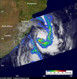
This image from NASA's TRMM satellite shows rainfall in the remnants of Tropical Cyclone Irina on March 5 at 2:23 a.m. local time/South Africa. Numerous intense storms in the southern and eastern quadrant were dropping rainfall at a rate of over 50mm per hr / ~2 inches (red). Light to moderate rainfall is depicted in blue and green was falling at a rate between .78 to 1.57 inches (20 to 40 mm) per hour. Credit: Credit: SSAI/NASA, Hal Pierce<br>
Irina is making a cyclonic loop, something that a tropical cyclone does on occasion whenever there are a couple of weather systems that push it in different directions.
On March 5, 2012, Irina's maximum sustained winds had increased to near 50 knots (57.5 mph/92.6 kph), , up from 40 knots (46 mph/74 kph) over the last several days. Forecasters at the Joint Typhoon Warning Center expect Irina to strengthen more at sea over the next day, and then begin to weaken.
CURRENT LOCATION
Irina is still centered at sea, and parallel to the middle of South Africa on March 5. Irina's center is about 315 nautical miles south-southeast of Maputo, Mozambique, and it was moving to the southeast, but is expected to start curving to the northeast and then northwest as it continues making a loop that will take it back toward a landfall in extreme northeastern South Africa.
What's making it loop? Weather systems in the area are pushing past Irina, acting as guides for the storm to follow. The last weather system that will turn it back to the north is a ridge (elongated area) of high pressure that's strengthening over South Africa will turn Irina to the northwest.
SATELLITE DATA
Infrared data from Atmospheric Infrared Sounder (AIRS) instrument on NASA's Aqua satellite showed on March 5, that most of the strongest thunderstorms and heaviest rainfall are occurring in the southern half of the storm. The strongest thunderstorms usually have the highest, and coldest cloud top temperatures, which is what AIRS infrared data reads. When cloud tops exceed the AIRS threshold of -63 Fahrenheit (-52.7 Celsius), the cloud tops are considered strong thunderstorms, and usually they have heavy rainfall. On the northern side of the storm, it's a different story, however, as sinking air on the northern side is preventing thunderstorm development.
NASA's Tropical Rainfall Measuring Mission (TRMM) satellite passed over Irina on March 5, 2012 at 0023 UTC (2:23 a.m. local time/South Africa / 7:23 p.m. EST on March 4, EST). A rainfall analysis from TRMM's Microwave Imager (TMI) and Precipitation Radar (PR) instruments showed areas of heavy rainfall in several areas, mostly south of the center of circulation. Areas with heavy rain were spotted by the TRMM satellite in the southwestern and eastern quadrants of the storm, and rain was falling at a rate of over 50mm/hr (~2 inches).
LANDFALL
Cyclone Irina is now expected to make landfall in extreme northeastern South Africa, south of the Mozambique border late on March 9, but the forecast could again change as Irina has been slowed by various weather factors. There are several parks located near where landfall is currently forecast. Tembe Elephant Park and the Ndumo Game Reserve are located near the Mozambique border and the Isimangaliso Wetland Park is located to the south. These areas are likely to feel the strongest winds from Irina when it makes landfall.
As Irina nears landfall by the end of the week, cold waters stirred up from below the surface are causing sea surface temperatures near the coast to cool, which will reduce any energy going into Irina as it nears the coast for landfall. Once Irina makes landfall, the forecasters at the Joint Typhoon Warning center expect Irina to dissipate quickly. Meanwhile residents of eastern South Africa, Swaziland and southeastern Mozambique can expect more clouds, showers, gusty winds and rough surf in coastal areas as Irina loops back toward land.
Media Contact
More Information:
http://www.nasa.govAll latest news from the category: Earth Sciences
Earth Sciences (also referred to as Geosciences), which deals with basic issues surrounding our planet, plays a vital role in the area of energy and raw materials supply.
Earth Sciences comprises subjects such as geology, geography, geological informatics, paleontology, mineralogy, petrography, crystallography, geophysics, geodesy, glaciology, cartography, photogrammetry, meteorology and seismology, early-warning systems, earthquake research and polar research.


Newest articles

Machine learning algorithm reveals long-theorized glass phase in crystal
Scientists have found evidence of an elusive, glassy phase of matter that emerges when a crystal’s perfect internal pattern is disrupted. X-ray technology and machine learning converge to shed light…

Mapping plant functional diversity from space
HKU ecologists revolutionize ecosystem monitoring with novel field-satellite integration. An international team of researchers, led by Professor Jin WU from the School of Biological Sciences at The University of Hong…

Inverters with constant full load capability
…enable an increase in the performance of electric drives. Overheating components significantly limit the performance of drivetrains in electric vehicles. Inverters in particular are subject to a high thermal load,…

