NASA satellites saw Tropical Depression Emily struggle over the weekend
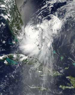
NASA's Aqua satellite captured this visible image on the reformed Tropical Depression Emily off the southern Florida coast on Aug. 6 at 2:25 p.m. EDT. Emily's northeastern edge was over Grand Bahama Island, and her northwestern edge was brushing southeastern Florida. Credit: NASA Goddard MODIS Rapid Response Team<br>
At 5 p.m. EDT on Saturday, August 6, Emily became a tropical depression for the second time in her life about 70 miles west-northwest of Great Abaco Island, near 26.9 North and 78.1 West. She was moving to the north at 8 mph and had a minimum central pressure of 1012 millibars. Maximum sustained winds were 30 mph.
At 18:25 UTC 2:25 p.m. EDT, the Moderate Resolution Imaging Spectroradiometer (MODIS) instrument on NASA's Aqua satellite captured a visible image of Tropical Depression Emily, centered between southern Florida and the northern Bahamas. Emily's northeastern edge was over Grand Bahama Island at that time. Emily's northwestern edge was brushing southeastern Florida.
A close look at the visible imagery shows higher thunderstorms around the center of circulation that were casting shadows on the lower surrounding thunderstorms. Those higher thunderstorms around the center were an indication of strengthening and Emily's winds did pick up that night.
At the same time, another instrument on NASA's Aqua satellite took an infrared image of Emily's cloud top temperatures. The Atmospheric Infrared Sounder (AIRS) instrument saw several areas around Emily's center of circulation with highest, coldest, cloud tops, where thunderstorms were the strongest and the heaviest rain was falling. Those areas appeared southwest of the center.
Her winds peaked on Sunday, August 7 at 11 a.m. EDT when they reached 35 mph. At that time, she was near 30.1 North and 76.0 West, about 300 miles southeast of Charleston, South Carolina.
By 5 p.m. EDT on Sunday, August 7, just 24 hours after regaining her stature as a tropical depression, she was dissipating. Her winds were back down to 30 mph, and she was moving to the northeast near 17 mph. Maximum sustained winds were near 30 mph and pressure was 1011 millibars.
Monday, August 8 revealed that Emily was now a remnant elongated low pressure area centered near 32 North and 73 West. The remnants are being absorbed into a frontal boundary to the north.
NASA's Hurricane page: www.nasa.gov/hurricane also on Facebook and Twitter: NASA Hurricane
Media Contact
More Information:
http://www.nasa.govAll latest news from the category: Earth Sciences
Earth Sciences (also referred to as Geosciences), which deals with basic issues surrounding our planet, plays a vital role in the area of energy and raw materials supply.
Earth Sciences comprises subjects such as geology, geography, geological informatics, paleontology, mineralogy, petrography, crystallography, geophysics, geodesy, glaciology, cartography, photogrammetry, meteorology and seismology, early-warning systems, earthquake research and polar research.


Newest articles

Bringing bio-inspired robots to life
Nebraska researcher Eric Markvicka gets NSF CAREER Award to pursue manufacture of novel materials for soft robotics and stretchable electronics. Engineers are increasingly eager to develop robots that mimic the…

Bella moths use poison to attract mates
Scientists are closer to finding out how. Pyrrolizidine alkaloids are as bitter and toxic as they are hard to pronounce. They’re produced by several different types of plants and are…

AI tool creates ‘synthetic’ images of cells
…for enhanced microscopy analysis. Observing individual cells through microscopes can reveal a range of important cell biological phenomena that frequently play a role in human diseases, but the process of…

