NASA satellites see Otto become a tropical storm
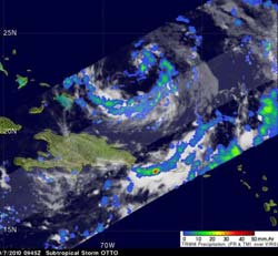
The Tropical Rainfall Measuring Mission (TRMM) satellite passed above Otto on October 7 at 0945 UTC (5:45 a.m. EDT) and the TRMM Precipitation Radar data revealed a feeder band in the southern part of the storm was dropping moderate to heavy (red) rainfall. The TRMM Microwave Imager indicated that convection in the center of the storm was generating thunderstorms. Credit: NASA/SSAI, Hal Pierce<br>
After a United States Air Force Reserve reconnaissance flight subtropical depression seventeen was upgraded by the National Hurricane Center (NHC) to subtropical storm Otto on Oct. 6 at 5 p.m. EDT (2100 UTC). On Oct. 6 and 7, NASA's TRMM and Aqua satellites were flying overhead measuring very cold, high thunderstorm cloud tops and heavy rainfall.
The Tropical Rainfall Measuring Mission (TRMM) satellite is managed by NASA and the Japanese Space Agency. At NASA's Goddard Space Flight Center in Greenbelt, Md., meteorologists create satellite imagery from TRMM data. When TRMM passed above Otto this morning, Oct. 7 at 0945 UTC (5:45 a.m. EDT) the TRMM Precipitation Radar data revealed a feeder band in the southern part of the storm was dropping moderate to heavy rainfall (falling at a rate as much as 2 inches per hour). Coverage from TRMM Microwave Imager data indicated that convection in the center of the storm was generating thunderstorms.
At 11 a.m. EDT on Oct. 7, Tropical Storm Otto had maximum sustained winds near 60 mph, and strengthening is likely, according to the National Hurricane Center. Otto could become a hurricane in the next day or two. Otto was located about 255 miles northeast of Grand Turk Island or 620 miles south-southwest of Bermuda near 23.8 North latitude and 68.0 West longitude. Otto is far away enough from any land areas that there are no watches or warnings in effect. Otto was slowly trudging through the Atlantic Ocean at 2 mph and moving northeast. Otto's minimum central pressure was 992 millibars.
Forecasters at the NHC said that “Otto has finally transitioned into a tropical cyclone based on an analysis of vertical temperatures on Oct. 7 at 0935 UTC (5:35 a.m. EDT)” from the University of Wisconsin-Cooperative Institute for Meteorological Satellite Services (CIMSS). CMISS analyzed data from the Advanced Microwave Sounding Unit (AMSU) instrument. AMSU is a multi-channel microwave radiometer installed on a number of satellites, including NASA's Aqua satellite and NOAA polar orbiting satellites. The AMSU instrument examines several bands of microwave radiation from the atmosphere to provide data on temperature and moisture levels throughout a tropical cyclone. CIMSS utilizes NASA satellite data and offers real-time and archived tropical cyclone products from it home (web) page. The AMSU data indicated that the warm core of Otto had “moved upward” from the mid-levels of the storm to the upper-levels, re-classifying the storm as “tropical” instead of “sub-tropical.”
Data from NASA's Atmospheric Infrared Sounder (AIRS) instrument also helped confirm the transition into a tropical storm. AIRS is an instrument that also flies aboard NASA's Aqua satellite. AIRS imagery showed a recent burst of deep convection, where the cloud top temperatures were near -80 Celsius (-112 Fahrenheit) over the center of Otto.
Microwave images are created when data from NASA's Aqua satellite AIRS and AMSU instruments are combined. A microwave image from data at 2:29 a.m. EDT on October 7 was created at NASA's Jet Propulsion Laboratory, Pasadena, Calif. The image indicated there was a large area of precipitation or ice in the cloud tops in Tropical Storm Otto.
Otto is meandering around, but a large trough (an elongated area of low pressure) that is along the U.S. East Coast is expected to continue moving east and push Otto into the open waters of the Atlantic over the next couple of days.
Media Contact
More Information:
http://www.nasa.govAll latest news from the category: Earth Sciences
Earth Sciences (also referred to as Geosciences), which deals with basic issues surrounding our planet, plays a vital role in the area of energy and raw materials supply.
Earth Sciences comprises subjects such as geology, geography, geological informatics, paleontology, mineralogy, petrography, crystallography, geophysics, geodesy, glaciology, cartography, photogrammetry, meteorology and seismology, early-warning systems, earthquake research and polar research.


Newest articles

Silicon Carbide Innovation Alliance to drive industrial-scale semiconductor work
Known for its ability to withstand extreme environments and high voltages, silicon carbide (SiC) is a semiconducting material made up of silicon and carbon atoms arranged into crystals that is…

New SPECT/CT technique shows impressive biomarker identification
…offers increased access for prostate cancer patients. A novel SPECT/CT acquisition method can accurately detect radiopharmaceutical biodistribution in a convenient manner for prostate cancer patients, opening the door for more…

How 3D printers can give robots a soft touch
Soft skin coverings and touch sensors have emerged as a promising feature for robots that are both safer and more intuitive for human interaction, but they are expensive and difficult…

