NASA satellites see Hurricane Celia strengthen and open an eye
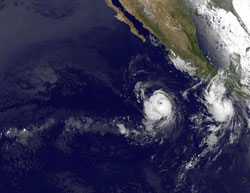
The GOES-11 satellite captured an image of Celia on June 23 at 8 a.m. EDT that shows the hurricane now has an eye. Located to the east of Celia on the far right of this image is the newly formed Tropical Storm Darby. Credit: NASA GOES Project<br>
Celia's maximum sustained winds were up to 100 mph at 11 a.m. EDT on June 23. That's a jump from the 80 mph maximum sustained winds it had just six hours earlier. Celia's hurricane force winds extend outward up to 30 miles (45 km) from the center and tropical storm force winds extend outward up to 105 miles (165 km).
Imagery taken this morning at 8 a.m. EDT from the Geostationary Operational Environmental Satellite known as GOES-11 revealed that Celia has an eye. The image also showed the newly formed Tropical Storm Darby to the east of Celia. The satellite image was created by NASA's GOES Project, located at NASA's Goddard Space Flight Center, Greenbelt, Md. GOES-11 is operated by the National Oceanic and Atmospheric Administration.
Two days ago on Monday, June 21, NASA's Aqua satellite flew over Celia and the Moderate Resolution Imaging Spectroradiometer (MODIS) instrument captured a true-color image of Celia that did not show an eye.
Currently, Celia is far from Mexico, some 740 miles south of the southern tip of Baja California, near 12.2 North latitude and 109.2 West longitude. Celia is moving west near 12 mph (19 km/hr) and has a minimum central pressure near 974 millibars. Celia is expected to turn toward the west-northwest in the next day or two and possibly strengthen.
Vertical wind shear is decreasing which has enabled Celia to strengthen. The National Hurricane Center in Miami, Fla. forecasts wind shear near Celia to continue weakening as low or lower than 6 mph (5 knots), which will enable Celia to strengthen a little more over the next 24 to 36 hours. However, Celia will also track into cooler waters, which will limit it's ability to power up, and as it continues west-northwest, it will begin weakening.
Media Contact
More Information:
http://www.nasa.govAll latest news from the category: Earth Sciences
Earth Sciences (also referred to as Geosciences), which deals with basic issues surrounding our planet, plays a vital role in the area of energy and raw materials supply.
Earth Sciences comprises subjects such as geology, geography, geological informatics, paleontology, mineralogy, petrography, crystallography, geophysics, geodesy, glaciology, cartography, photogrammetry, meteorology and seismology, early-warning systems, earthquake research and polar research.


Newest articles

Security vulnerability in browser interface
… allows computer access via graphics card. Researchers at Graz University of Technology were successful with three different side-channel attacks on graphics cards via the WebGPU browser interface. The attacks…

A closer look at mechanochemistry
Ferdi Schüth and his team at the Max Planck Institut für Kohlenforschung in Mülheim/Germany have been studying the phenomena of mechanochemistry for several years. But what actually happens at the…

Severe Vulnerabilities Discovered in Software to Protect Internet Routing
A research team from the National Research Center for Applied Cybersecurity ATHENE led by Prof. Dr. Haya Schulmann has uncovered 18 vulnerabilities in crucial software components of Resource Public Key…

