NASA satellites and Global Hawk see Nadine display more tropical characteristics
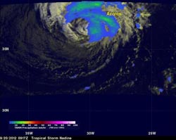
NASA's TRMM satellite flew over Nadine on Sept. 20 at 5:17 a.m. EDT and gathered rainfall data. TRMM saw the maximum intensity of rainfall is about 20 mm/hr (~ .8 inches). The Azores is shown being affected by a rain band from Nadine. <br><br>Credit: NASA/SSAI, Hal Pierce<br>
Forecasters noted that Nadine could have started transitioning into an extra-tropical storm, because there was little significant rainfall near Nadine's center of circulation yesterday, Sept. 19. However, satellite data and data gathered from NASA's Global Hawk during a flight in the Hurricane and Severe Storm Sentinels (HS3) campaign on Sept. 19 and 20, showed that wasn't happening yet.
NASA's TRMM Satellite Measures Nadine's Rainfall from Space
The Tropical Rainfall Measuring Mission (TRMM) satellite flew over Nadine on Sept. 20 at 0917 UTC (5:17 a.m. EDT) and gathered rainfall data. “TRMM data showed that convection developed near Nadine's center, indicating that Nadine is more characteristic of a tropical cyclone than expected,” said Hal Pierce, of NASA's Goddard Space Flight Center in Greenbelt, Md.
Hal overlaid the data from TRMM's Visible and InfraRed Scanner (VIRS) and TRMM's Microwave Imager (TMI) to create a full picture of rainfall occurring in the storm. The rainfall analysis indicated that the maximum intensity of rainfall is about 20 mm/hr (~ 0.8 inches). The Azores is shown being affected by a rain band from Nadine. Infrared satellite data revealed that convection (rising air that form the thunderstorms that make up the cyclone) around Nadine's inner-core has increased and become better organized since Sept. 19. Infrared data also indicated an eye-like feature.
TRMM is a joint mission of NASA and the Japanese Space Agency, JAXA.
NASA's HS3 Global Hawk Examines Nadine
As part of the HS3 mission, NASA's Global Hawk unmanned aircraft took off from the NASA Wallops Flight Facility, Wallops, Va. at 2:42 p.m. EDT on Wednesday, Sept. 19 and crossed the Atlantic to make measurement of Tropical Storm Nadine. Nadine is currently located in the Atlantic a few hundred miles southwest of the Azores Island chain.
The science portion of the flight was completed on Sept. 20. Scientists reported that they obtained excellent data from the dropsonde system, which showed some winds on the western side of the storm still reaching 60 knots (69 mph/111 kmh) at middle levels and possibly one measurement of near 60 knots (69 mph/111 kmh) near the surface. The data suggest that Nadine is still a tropical system rather than extratropical. The National Hurricane Center mentioned the data in their morning discussion of Nadine.
The three science instruments aboard the Global Hawk performed extremely well, transmitting their data back to NASA Wallops for the scientists to analyze and discuss. The plane observed Nadine for more than 12 hours. This was the 3rd flight of the Global Hawk to investigate this tropical storm. The forecasters at the National Hurricane Center were using the data supplied by NASA's Global Hawk and noted in the discussion of Nadine at 11 a.m. EDT on Sept. 20, “The current intensity is kept at 45 knots (51.7 mph/83.3 kmh)…is in good agreement with dropsonde data from the NASA global hawk aircraft and AMSU [instrument] estimates.”
Nadine's Current Status
As Nadine pulls away, a tropical storm warning was still in effect on Sept. 20 for the islands of Flores, Corvo, Faial, Pico, Sao Jorge, Graciosa, Terceira, Sao Miguel and Santa Maria in the Azores. These areas are also expected to continue dealing with rough ocean swells over the next few days.
On Sept. 20 at 11 a.m. EDT, Nadine was located 165 miles (265 km) south-southwest of Pico in the Azores Islands. It was centered near 36.2 North latitude and 29.4 West longitude. Nadine's maximum sustained winds were near 50 mph (85 kmh). Nadine was moving to the east-southeast at 10 mph (17 kmh) and had a minimum central pressure of 981 millibars.
Nadine's atmospheric steering mechanism, a strong mid-tropospheric trough (elongated area) of low pressure is expected to move to the northeast, and leave the tropical storm in a region of weaker steering winds, so Nadine could start meandering over the next couple of days.
Media Contact
More Information:
http://www.nasa.govAll latest news from the category: Earth Sciences
Earth Sciences (also referred to as Geosciences), which deals with basic issues surrounding our planet, plays a vital role in the area of energy and raw materials supply.
Earth Sciences comprises subjects such as geology, geography, geological informatics, paleontology, mineralogy, petrography, crystallography, geophysics, geodesy, glaciology, cartography, photogrammetry, meteorology and seismology, early-warning systems, earthquake research and polar research.


Newest articles

High-energy-density aqueous battery based on halogen multi-electron transfer
Traditional non-aqueous lithium-ion batteries have a high energy density, but their safety is compromised due to the flammable organic electrolytes they utilize. Aqueous batteries use water as the solvent for…

First-ever combined heart pump and pig kidney transplant
…gives new hope to patient with terminal illness. Surgeons at NYU Langone Health performed the first-ever combined mechanical heart pump and gene-edited pig kidney transplant surgery in a 54-year-old woman…

Biophysics: Testing how well biomarkers work
LMU researchers have developed a method to determine how reliably target proteins can be labeled using super-resolution fluorescence microscopy. Modern microscopy techniques make it possible to examine the inner workings…

