NASA satellites confirm Tropical Storm Bret's heaviest rains on the eastern side
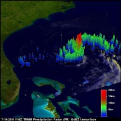
NASA's TRMM satellite captured this image of rainfall happening within Tropical Stort on July 19. The strongest thunderstorms were as high as 9.3 miles (15 km) and had the heaviest rainfall (red) on the east side of the storm, falling at 2 inches (50 mm) per hour. The yellow and green areas indicate moderate rainfall between .78 to 1.57 inches (20 to 40 mm) per hour. Credit: NASA/SSAI, Hal Pierce<br>
The Tropical Rainfall Measuring Mission (TRMM) satellite flew over tropical storm Bret in the Atlantic Ocean north of the Bahamas on July 19, 2011 at 1118 UTC ( 7:18 a.m. EDT). The early morning pass showed that Bret was very small but TRMM's Precipitation Radar showed that the storm had some powerful thunderstorms reaching to heights of 15km (9.3 miles) in the eastern quadrant of the storm.
NASA's Aqua satellite passed over Tropical Storm Bret seven hours later than TRMM did on July 19 at 18:35 UTC (2:35 p.m. EDT). NASA's Atmospheric Infrared Sounder (AIRS) imagery confirmed what TRMM showed by measuring very cold (-63F/-52C) cloud top temperatures. Bret still had strong thunderstorms east of the center of circulation.
At 5 a.m. EDT Tropical Storm Bret's maximum sustained winds were near 50 mph (85 kmh) although gradual weakening is forecast to occur over the next two days. Bret's center is near latitude 31.1 North and longitude 74.4 West. Bret is moving toward the northeast near 7 mph (11 kmh) and is expected to continue in that direction while speeding up. Bret's minimum central pressure is 1001 millibars.
Bret is forecast to run into strong wind shear and dry air, two factors that will take the wind out of his sails in the next couple of days.
Media Contact
More Information:
http://www.nasa.govAll latest news from the category: Earth Sciences
Earth Sciences (also referred to as Geosciences), which deals with basic issues surrounding our planet, plays a vital role in the area of energy and raw materials supply.
Earth Sciences comprises subjects such as geology, geography, geological informatics, paleontology, mineralogy, petrography, crystallography, geophysics, geodesy, glaciology, cartography, photogrammetry, meteorology and seismology, early-warning systems, earthquake research and polar research.


Newest articles

Superradiant atoms could push the boundaries of how precisely time can be measured
Superradiant atoms can help us measure time more precisely than ever. In a new study, researchers from the University of Copenhagen present a new method for measuring the time interval,…

Ion thermoelectric conversion devices for near room temperature
The electrode sheet of the thermoelectric device consists of ionic hydrogel, which is sandwiched between the electrodes to form, and the Prussian blue on the electrode undergoes a redox reaction…

Zap Energy achieves 37-million-degree temperatures in a compact device
New publication reports record electron temperatures for a small-scale, sheared-flow-stabilized Z-pinch fusion device. In the nine decades since humans first produced fusion reactions, only a few fusion technologies have demonstrated…

