NASA Satellites Capture a Stronger La Nina
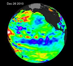
The La Niña is evident by the large pool cooler than normal (blue and purple) water stretching from the eastern to the central Pacific Ocean, reflecting lower than normal sea surface heights. \\\"This La Niña has strengthened for the past seven months, and is one of the most intense events of the past half century,\\\" said Climatologist Bill Patzert of NASA JPL. Credit: NASA JPL/Bill Patzert<br>
A new Ocean Surface Topography Mission (OSTM)/Jason-2 satellite image of the Pacific Ocean that averaged 10 days of data was just released from NASA. The image, centered on Dec. 26, 2010, was created at NASA's Jet Propulsion Laboratory (JPL), Pasadena, Calif.
“The solid record of La Niña strength only goes back about 50 years and this latest event appears to be one of the strongest ones over this time period,” said Climatologist Bill Patzert of JPL. “It is already impacting weather and climate all around the planet.”
“Although exacerbated by precipitation from a tropical cyclone, rainfalls of historic proportion in eastern Queensland, Australia have led to levels of flooding usually only seen once in a century,” said David Adamec, Oceanographer at NASA's Goddard Space Flight Center, Greenbelt, Md. “The copious rainfall is a direct result of La Niña’s effect on the Pacific trade winds and has made tropical Australia particularly rainy this year.”
The new image depicts places where the Pacific sea surface height is near-normal, higher (warmer) than normal and lower (cooler) than normal. The cooler-than normal pool of water that stretches from the eastern to the central Pacific Ocean is a hallmark of a La Niña event.
Earth's ocean is the greatest influence on global climate. Only from space can we observe our vast ocean on a global scale and monitor critical changes in ocean currents and heat storage. Continuous data from satellites like OSTM/Jason-2 help us understand and foresee the effects of ocean changes on our climate and on climate events such as La Niña and El Niño.
The latest report from NOAA's Climate Prediction Center (CPC) noted that “A moderate-to-strong La Niña continued during December 2010 as reflected by well below-average sea surface temperatures (SSTs) across the equatorial Pacific Ocean.” The CPC report said that La Niña is expected to continue well into the Northern Hemisphere spring 2011.
Rob Gutro
NASA's Goddard Space Flight Center
Media Contact
All latest news from the category: Earth Sciences
Earth Sciences (also referred to as Geosciences), which deals with basic issues surrounding our planet, plays a vital role in the area of energy and raw materials supply.
Earth Sciences comprises subjects such as geology, geography, geological informatics, paleontology, mineralogy, petrography, crystallography, geophysics, geodesy, glaciology, cartography, photogrammetry, meteorology and seismology, early-warning systems, earthquake research and polar research.


Newest articles

Superradiant atoms could push the boundaries of how precisely time can be measured
Superradiant atoms can help us measure time more precisely than ever. In a new study, researchers from the University of Copenhagen present a new method for measuring the time interval,…

Ion thermoelectric conversion devices for near room temperature
The electrode sheet of the thermoelectric device consists of ionic hydrogel, which is sandwiched between the electrodes to form, and the Prussian blue on the electrode undergoes a redox reaction…

Zap Energy achieves 37-million-degree temperatures in a compact device
New publication reports record electron temperatures for a small-scale, sheared-flow-stabilized Z-pinch fusion device. In the nine decades since humans first produced fusion reactions, only a few fusion technologies have demonstrated…

