NASA satellites capture 3 days of Hurricane Gordon's Atlantic track
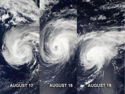
These three images from the MODIS instrument on NASA's Terra and Aqua satellites were captured on Aug. 17-19 and show the progression of Hurricane Gordon through the eastern Atlantic Ocean.<br><br>Credit: NASA Goddard MODIS Rapid Response Team<br>
The Moderate Resolution Imaging Spectroradiometer, or MODIS, is an instrument that flies onboard NASA's Terra and Aqua satellites and provides high-resolution imagery to users. When NASA's Terra satellite flew over Gordon on August 17 at 9:30 a.m. EDT it was a tropical storm and did not have a visible eye.
It was followed up by a fly over of NASA's Aqua satellite on August 18 at 11:50 a.m. EDT, it had strengthened into a hurricane and had a clear and visible eye. On August 19, Gordon was still a hurricane at 10:55 a.m. EDT when NASA's Aqua satellite again passed over the storm. At that time, Gordon was affecting the Azores Islands. Ocean swells in the eastern Azores generated by Gordon are expected to start subsiding today, August 20, as Gordon moves east and toward Portugal.
At 8 a.m. EDT (1200 UTC) on August 20, Gordon weakened back to tropical storm status with maximum sustained winds near 70 mph (110 kmh). The center of Tropical Storm Gordon was located about 115 miles (180 km) east-northeast of Santa Maria Island in the Azores, near latitude 37.7 north and longitude 23.2 west. The National Hurricane Center noted that Gordon is moving toward the east-northeast near 15 mph (24 kmh) and is expected to slow and turn east.
The National Hurricane Center expects Tropical Storm Gordon to become extra-tropical later in the day on August 20.
Media Contact
More Information:
http://www.nasa.govAll latest news from the category: Earth Sciences
Earth Sciences (also referred to as Geosciences), which deals with basic issues surrounding our planet, plays a vital role in the area of energy and raw materials supply.
Earth Sciences comprises subjects such as geology, geography, geological informatics, paleontology, mineralogy, petrography, crystallography, geophysics, geodesy, glaciology, cartography, photogrammetry, meteorology and seismology, early-warning systems, earthquake research and polar research.


Newest articles

Superradiant atoms could push the boundaries of how precisely time can be measured
Superradiant atoms can help us measure time more precisely than ever. In a new study, researchers from the University of Copenhagen present a new method for measuring the time interval,…

Ion thermoelectric conversion devices for near room temperature
The electrode sheet of the thermoelectric device consists of ionic hydrogel, which is sandwiched between the electrodes to form, and the Prussian blue on the electrode undergoes a redox reaction…

Zap Energy achieves 37-million-degree temperatures in a compact device
New publication reports record electron temperatures for a small-scale, sheared-flow-stabilized Z-pinch fusion device. In the nine decades since humans first produced fusion reactions, only a few fusion technologies have demonstrated…

