NASA Satellites Calling Here You Come Again, Tropical Storm Dolly
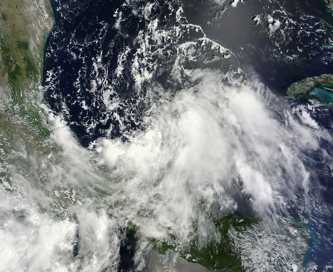
On Sept. 1 at 12:45 p.m. EDT NASA's Terra satellite caught this image of the low pressure area that would become Tropical Storm Dolly, while it was moving over the Yucatan Peninsula. Image Credit: NASA Goddard's MODIS Rapid Response Team
In July of 2008, Tropical Storm Dolly made landfall on Mexico's Yucatan Peninsula of Mexico before making a second and final landfall in south Texas. Now, six years later, Tropical Storm Dolly returns thanks to the six year list of revolving hurricane names, and once again Dolly is making landfall in eastern Mexico. NASA's Aqua satellite caught Dolly developing over the Yucatan and poised for a second landfall in eastern Mexico today, September 2.
On Sept. 1 at 12:45 p.m. EDT NASA's Terra satellite caught an image of the low pressure area that would become Tropical Storm Dolly, while it was moving over the Yucatan Peninsula. By September 2, the low developed into a tropical storm. The image, taken by the Moderate Resolution Imaging Spectroradiometer or MODIS instrument, showed the low pressure area as somewhat shapeless as it passed over the Yucatan. Once it slid west and entered the warm waters of the Bay of Campeche, it began to develop more.
An animation of visible and infrared satellite imagery from NOAA's GOES-East satellite was created by the NASA/NOAA GOES Project at NASA's Goddard Space Flight Center in Greenbelt, Maryland. The animation showed the birth and movement of Dolly from August 31 to September 2. On August 31, Dolly was not yet named and was a low pressure area from the western Caribbean Sea that moved over the Yucatan Peninsula. The animation shows the development of the storm as the low moved across the Bay of Campeche.
The Atmospheric Infrared Sounder or AIRS instrument aboard NASA's Aqua satellite captured infrared data on Tropical Storm Dolly on Sept. 2 at 3:59 a.m. EDT as it neared the east coast of Mexico. The data was made into a false-colored image at NASA's Jet Propulsion Laboratory in Pasadena, California. The AIRS image showed the strongest thunderstorms were on the eastern side of the center of circulation, where cloud tops stretched toward the top of the troposphere. Cloud tops in that area were as cold as -63F/-52C, indicative of high, strong thunderstorms. NASA research shows that thunderstorms with cloud top temperatures that cold have the potential for dropping heavy rainfall.
By September 2 at 8 a.m. EDT (1200 UTC) the center of Tropical Storm Dolly was located near latitude 23.0 north and longitude 95.7 west. That puts Dolly's center about 145 miles (230 km) east-southeast of la Pesca, Mexico. Dolly was moving toward the west-northwest near 13 mph (20 kph) and the center of the storm is expected to approach the coast by tonight, September 2, and move inland tomorrow.
Maximum sustained winds have increased to near 50 mph (85 kph) and the National Hurricane Center (NHC) noted that some strengthening is possible until Dolly makes landfall. Tropical-storm-force winds extend outward up to 115 miles (185 km) mostly northeast through southeast of the center.
A tropical storm warning is in force from Tuxpan to Barra el Mezquital. The NHC noted that rainfall totals of 3 to 6, locally up to 10 inches are possible in southern Tamaulipas, northern Veracruz and eastern San Luis Potosi. Those heavy rains will likely cause flash flooding and mudslides in regions of mountainous terrain and that threat will continue as Dolly moves inland.
Rob Gutro
NASA's Goddard Space Flight Center, Greenbelt, Maryland
Media Contact
All latest news from the category: Earth Sciences
Earth Sciences (also referred to as Geosciences), which deals with basic issues surrounding our planet, plays a vital role in the area of energy and raw materials supply.
Earth Sciences comprises subjects such as geology, geography, geological informatics, paleontology, mineralogy, petrography, crystallography, geophysics, geodesy, glaciology, cartography, photogrammetry, meteorology and seismology, early-warning systems, earthquake research and polar research.


Newest articles

High-energy-density aqueous battery based on halogen multi-electron transfer
Traditional non-aqueous lithium-ion batteries have a high energy density, but their safety is compromised due to the flammable organic electrolytes they utilize. Aqueous batteries use water as the solvent for…

First-ever combined heart pump and pig kidney transplant
…gives new hope to patient with terminal illness. Surgeons at NYU Langone Health performed the first-ever combined mechanical heart pump and gene-edited pig kidney transplant surgery in a 54-year-old woman…

Biophysics: Testing how well biomarkers work
LMU researchers have developed a method to determine how reliably target proteins can be labeled using super-resolution fluorescence microscopy. Modern microscopy techniques make it possible to examine the inner workings…

