NASA Satellite Sees Tropical Storm Cyril a Strong, Compact Storm
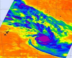
This infrared image was taken from the AIRS instrument on NASA's Aqua satellite, on February 7, 2012 at 12:29 UTC. Cyril is still a very compact, rounded storm. The strongest thunderstorms remain close to the center of circulation (purple) where cloud top temperatures are below -63 F (-52.7C). Credit: NASA/JPL, Ed Olsen<br>
In the morning hours of February 7 (local time Vanuatu) Cyril was located south of the island of Vavau in the Kingdom of Tonga. All warnings for Niue and Tonga have now been cancelled.
During the morning hours of February 7, Cyril picked up speed and is moving to the southeast at 28 knots (~32 mph/~52 kph). Cyril's maximum sustained winds were near 45 knots (~52 mph/~83 kph). Those tropical-storm-force winds only extended out to 35 miles (~56 km), making the storm over 70 miles (~113 km) in diameter. Satellite imagery from February 6 helped forecasters estimate that the clouds associated with Cyril extended to 120 miles in diameter.
By 1500 UTC on February 7 (10 a.m. EST or 4 a.m. on Feb. 8 Pacific/Tongatapu local time) Cyril was centered about 545 nautical miles (627 miles/1,009 km) south of Pago Pago, American Samoa near 23.8 South and 165.0 West. Cyril covered 175 nautical miles (~196 miles/~315 km) in 12 hours during the morning hours of February 7.
The Atmospheric Infrared Sounder (AIRS) instrument on NASA's Aqua satellite captured an infrared image of Cyril's clouds on February 7, 2012 at 12:29 UTC. Cyril still appears as a very compact, rounded storm. The strongest thunderstorms remained close to the center of circulation where cloud top temperatures are below -63 F (-52.7C).
The Australian Broadcasting Corporation noted that the Vavau airport reported sustained winds of 45 knots (~52 mph/~83 kph) on Feb. 8 at 6:30 a.m. local Pacific/Tongatapu time.
As Cyril continues to speed to the southeast, the vertical wind shear is forecast to increase and sea surface temperatures are expected to be much cooler. In fact, water temperatures will decrease to 25 degrees Celsius (77F) and colder. Sea surface temperatures must be at least 26.6C (80F) to support a tropical cyclone, otherwise the system begins to weaken. The Joint Typhoon Warning Center gives Cyril two days before it dissipates.
Text Credit: Rob Gutro
NASA's Goddard Space Flight Center, Greenbelt, Md.
Media Contact
More Information:
http://www.nasa.govAll latest news from the category: Earth Sciences
Earth Sciences (also referred to as Geosciences), which deals with basic issues surrounding our planet, plays a vital role in the area of energy and raw materials supply.
Earth Sciences comprises subjects such as geology, geography, geological informatics, paleontology, mineralogy, petrography, crystallography, geophysics, geodesy, glaciology, cartography, photogrammetry, meteorology and seismology, early-warning systems, earthquake research and polar research.


Newest articles

Combatting disruptive ‘noise’ in quantum communication
In a significant milestone for quantum communication technology, an experiment has demonstrated how networks can be leveraged to combat disruptive ‘noise’ in quantum communications. The international effort led by researchers…

Stretchable quantum dot display
Intrinsically stretchable quantum dot-based light-emitting diodes achieved record-breaking performance. A team of South Korean scientists led by Professor KIM Dae-Hyeong of the Center for Nanoparticle Research within the Institute for…

Internet can achieve quantum speed with light saved as sound
Researchers at the University of Copenhagen’s Niels Bohr Institute have developed a new way to create quantum memory: A small drum can store data sent with light in its sonic…

