NASA satellite sees thunderstorms banding around developing system 96W
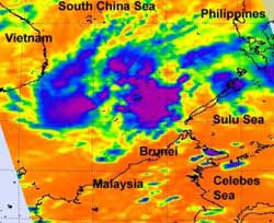
When NASA's Aqua satellite passed over System 96W on March 27 it captured this infrared image of the low pressure area. Aqua captured an infrared image of the storm's cloud top temperatures using the Atmospheric Infrared Sounder (AIRS) instrument. AIRS data showed that the strongest thunderstorms (purple) have cloud top temperatures colder than 230 degrees Kelvin (-45.6 F/-43.1C), indicating they're high in the troposphere and strong storms. Those storms were in bands east and west of the center. Credit: NASA/JPL, Ed Olsen<br>
NASA's Aqua satellite passed over the low pressure area called “System 96W” on March 27 at 0547 UTC (1:47 a.m. EDT) and the Atmospheric Infrared Sounder (AIRS) instrument captured an infrared and visible look at the storm.
On March 27, 2012 at 0600 UTC (2 a.m. EDT), System 96W was located in the western North Pacific Ocean about 205 miles north-northwest of Bandar Seri Begawan, Brunei, near 7.9 North and 113.4 East. Brunei is located north of the island of Borneo in southeastern Asia. It has a shoreline on the South China Sea, and surrounded by the state of Sarawak, Malaysia.
System 96W's maximum sustained winds are currently estimated as high as only 15 knots (17.2 mph/27.7 kph) with stronger gusts in the northwestern quadrant.
The NASA AIRS infrared imagery showed that the center of circulation is consolidating, and there are bands of thunderstorms wrapping along the eastern and western halves of the storm. The AIRS infrared data shows two large areas of convection (rising air that forms thunderstorms that make up the tropical cyclone) east and west of the center. Some of those storms have cloud top temperatures colder than 230 degrees Kelvin (-45.6 F/-43.1C), indicating they're high in the troposphere and strong storms. Storms with cloud heights that cold usually have heavy rainfall.
Forecasters at the Joint Typhoon Warning Center have upped the chance to “medium” for System 96W to strengthen into a tropical depression, based on wind shear remaining week, warm sea surface temperatures.
Media Contact
More Information:
http://www.nasa.govAll latest news from the category: Earth Sciences
Earth Sciences (also referred to as Geosciences), which deals with basic issues surrounding our planet, plays a vital role in the area of energy and raw materials supply.
Earth Sciences comprises subjects such as geology, geography, geological informatics, paleontology, mineralogy, petrography, crystallography, geophysics, geodesy, glaciology, cartography, photogrammetry, meteorology and seismology, early-warning systems, earthquake research and polar research.


Newest articles

High-energy-density aqueous battery based on halogen multi-electron transfer
Traditional non-aqueous lithium-ion batteries have a high energy density, but their safety is compromised due to the flammable organic electrolytes they utilize. Aqueous batteries use water as the solvent for…

First-ever combined heart pump and pig kidney transplant
…gives new hope to patient with terminal illness. Surgeons at NYU Langone Health performed the first-ever combined mechanical heart pump and gene-edited pig kidney transplant surgery in a 54-year-old woman…

Biophysics: Testing how well biomarkers work
LMU researchers have developed a method to determine how reliably target proteins can be labeled using super-resolution fluorescence microscopy. Modern microscopy techniques make it possible to examine the inner workings…

