NASA Satellite Sees Fading Rainfall in Tropical Storm Nadine
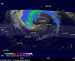
NASA's TRMM captured Nadine's rainfall rates at 6:13 a.m. EDT on Sept. 19, and showed no rainfall was occurring near Nadine's center. Rainfall around Nadine's center was falling at 20mm~0.8 inches per hour. Nadine's past and predicted path with appropriate symbols is shown overlaid in white. (Credit: SSAI/NASA, Hal Pierce)<br>
A tropical storm warning is in effect on Sept. 19 for the islands of Flores, Corvo, Faial, Pico, Sao Jorge, Graciosa, Terceira, Sao Miguel and Santa Maria in the Azores.
The Tropical Rainfall Measuring Mission (TRMM) satellite flew over Nadine on Sept. 19 at 1013 UTC (6:13 a.m. EDT) and captured data on rainfall rates occurring within the tropical storm. TRMM's Microwave Imager (TMI) and Precipitation Radar (PR) data showed that no rainfall was occurring near Nadine's center. The maximum precipitation intensity found in rain bands around Nadine was only about 0.8 inches (20mm) per hour. The lack of convection (rising air that forms the thunderstorms that make up the tropical cyclone) is a sign that the tropical storm is decaying or weakening.
NASA's Hurricane Severe Storms Sentinel (HS3) Mission plans to send one of the unmanned Global Hawk aircraft to investigate Nadine again on Wednesday, Sept. 19.
On Sept. 19 at 11 a.m. EDT Tropical Storm Nadine's maximum sustained winds were near 50 mph (85 kmh). Nadine was located about 270 miles (430 km) west of the Azores islands, near 37.2 north latitude and 31.8 west longitude. Nadine is moving toward the north-northeast near 5 mph (7 kmh) and is expected to start drifting to the east-southeast. Nadine's estimated minimum central pressure was 993 millibars.
According to the National Hurricane Center, early on Sept. 19, Corvo in the Azores reported sustained winds of 42 mph (68 kmh) with a gust to 58 mph (93 kmh). In addition, ocean swells continue to affect the Azores and are causing life-threatening surf conditions and rip tides.
The National Hurricane Center noted that if Nadine continues to show weaker convection, it may no longer qualify as a tropical or subtropical cyclone.
Text credit: Rob Gutro
NASA's Goddard Space Flight Center, Greenbelt, Md.
Media Contact
More Information:
http://www.nasa.govAll latest news from the category: Earth Sciences
Earth Sciences (also referred to as Geosciences), which deals with basic issues surrounding our planet, plays a vital role in the area of energy and raw materials supply.
Earth Sciences comprises subjects such as geology, geography, geological informatics, paleontology, mineralogy, petrography, crystallography, geophysics, geodesy, glaciology, cartography, photogrammetry, meteorology and seismology, early-warning systems, earthquake research and polar research.


Newest articles

Properties of new materials for microchips
… can now be measured well. Reseachers of Delft University of Technology demonstrated measuring performance properties of ultrathin silicon membranes. Making ever smaller and more powerful chips requires new ultrathin…

Floating solar’s potential
… to support sustainable development by addressing climate, water, and energy goals holistically. A new study published this week in Nature Energy raises the potential for floating solar photovoltaics (FPV)…

Skyrmions move at record speeds
… a step towards the computing of the future. An international research team led by scientists from the CNRS1 has discovered that the magnetic nanobubbles2 known as skyrmions can be…

