NASA satellite sees birth of Tropical Storm Ethel, now threatening Rodrigues
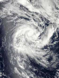
NASA's Aqua satellite passed over Tropical Storm Ethel in the Southern Indian Ocean on Jan. 19, 2012, at 09:30 UTC (4:30 a.m. EST). The MODIS instrument aboard Aqua captured a visible image of the storm, and showed that it had good circulation with an identifiable center of circulation. Credit: NASA Goddard MODIS Rapid Response Team<br>
When Aqua passed over newborn Ethel at 09:30 UTC (4:30 a.m. EST) on Jan. 19, the Moderate Resolution Imaging Spectroradiometer (MODIS) instrument aboard Aqua captured a visible image of the storm, and showed that it had good circulation. The strongest storms appear to be around the center and northwest of center. Bands of thunderstorms from the east-southeast appear to spiral into Ethel's center on the MODIS satellite imagery.
At 0300 UTC on January 19 (10 p.m. EST, Jan. 18) Tropical Storm Ethel had maximum sustained winds near 35 knots (40 mph/65 kmh). Ethel was 810 miles east-northeast of La Reunion Island, centered near 14.2 South longitude and 67.7 East latitude. Ethel was moving to the west-southwest at 11 knots (~13 mph/20 kmh).
Currently, Ethel threatens the island of Rodrigues. Rodrigues is the smallest of the Mascarene Islands and was home to 40,000 people in 2006. It is a dependency of Mauritius. According to Wikipedia, it is located 348 miles (560 km) east of Mauritius island. It is surrounded by a coral reef and about 43 square miles (109 km²).
The Mauritus Meteorological Service (MMS) has posted a tropical cyclone class two warning for Rodrigues. A class two warning means that within 12 hours, the warning area will likely experience hurricane-force wind gusts of 75 mph (120 kilometers) per hour. The MMS calls for downpours and gusty winds today, with rain becoming heavier and more frequent on January 20. Sustained winds are expected to be near 25 mph (40 kmh) with gusts as high as 56 mph (90 kmh) during the evening hours on Jan. 19, 2012. Seas are expected to be rough. For updates in French and Creole, visit: http://metservice.intnet.mu/?page_id=625.
Because Ethel is in an area with warm sea surface temperatures (warmer than the 80F/26.6C threshold needed to maintain a tropical cyclone) and low wind shear, she is expected to strengthen quickly into hurricane (cyclone) strength. Afterward, Ethel is expected to encounter increased wind shear conditions which will again weaken the storm.
The cyclone is forecast to intensify rapidly to hurricane strength before adverse atmospheric conditions prompt a weakening trend.
Media Contact
More Information:
http://www.nasa.govAll latest news from the category: Earth Sciences
Earth Sciences (also referred to as Geosciences), which deals with basic issues surrounding our planet, plays a vital role in the area of energy and raw materials supply.
Earth Sciences comprises subjects such as geology, geography, geological informatics, paleontology, mineralogy, petrography, crystallography, geophysics, geodesy, glaciology, cartography, photogrammetry, meteorology and seismology, early-warning systems, earthquake research and polar research.


Newest articles

High-energy-density aqueous battery based on halogen multi-electron transfer
Traditional non-aqueous lithium-ion batteries have a high energy density, but their safety is compromised due to the flammable organic electrolytes they utilize. Aqueous batteries use water as the solvent for…

First-ever combined heart pump and pig kidney transplant
…gives new hope to patient with terminal illness. Surgeons at NYU Langone Health performed the first-ever combined mechanical heart pump and gene-edited pig kidney transplant surgery in a 54-year-old woman…

Biophysics: Testing how well biomarkers work
LMU researchers have developed a method to determine how reliably target proteins can be labeled using super-resolution fluorescence microscopy. Modern microscopy techniques make it possible to examine the inner workings…

