NASA satellite reveals some strong rainfall in meandering Typhoon Prapiroon
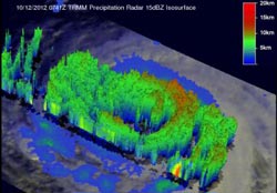
This 3-D view of Typhoon Prapiroon was taken from the northwest on Oct. 12, 2012, and clearly shows the vertical structure of Prapiroon's precipitation. The strongest rainfall (50 mm/2 inches per hour) was found in the southeastern side of Prapiroon's eye wall.<br><br>Credit: SSAI/NASA, Hal Pierce<br>
The Tropical Rainfall Measuring Mission (TRMM) satellite passed directly above weakening Typhoon Prapiroon in the western Pacific Ocean on October 12, 2012 at 0741 UTC (3:41 a.m. EDT). At that time, Typhoon Prapiroon was a powerful category two typhoon on the Saffir-Simpson scale with winds slightly less than 95 knots (~109 mph).
A 3-D image of the storm was created at NASA's Goddard Space Flight Center in Greenbelt, Md. using data on Oct. 12 gathered from TRMM's Precipitation Radar data. The view, taken from the northwest, clearly showed the vertical structure of Prapiroon's precipitation and cloud heights. The strongest rainfall was found in the southeastern side of Prapiroon's eye wall and was falling at a rate of 50 mm/2 inches per hour. Thunderstorm cloud tops in that vicinity were as high as 15 kilometers (9 miles), indicating strong storms. To see a flyby video of the Prapiroon in 3-D: http://trmm.gsfc.nasa.gov/trmm_rain/Events/prapiroon_12_october_2012_0741_
utc_trmm_radar_animated.gif
On Oct. 15 at 1500 UTC (11 a.m. EDT) Prapiroon was still quasi-stationary. It was weaker, though, packing maximum sustained winds near 75 knots (86.3 mph/138.9 kph) and was located near 22.4 North latitude and 131.0 East longitude. That put the storm's center about 305 nautical miles (403 miles/648 km) southeast of Kadena Air Base, Okinawa, Japan.
Satellite imagery on Oct. 15 showed that the cloud top temperatures around Prapiroon's eye had warmed, indicating that there was not as much power or uplift within the storm. Warming cloud top temperatures mean that the thunderstorms that make up the tropical cyclone are lower in the atmosphere than they were before, and they're weaker than before.
After another day of meandering, Prapiroon is expected to start tracking to the north-northeast because a ridge (elongated area) of high pressure is building in from the east and its air flow in a clockwise direction, will push Prapiroon around it and toward the northeast. Once it starts moving, Prapiroon's center is expected to stay over open water. However, the storm's western fringes are expected to brush eastern Japan later in the week of Oct. 15.
Media Contact
More Information:
http://www.nasa.govAll latest news from the category: Earth Sciences
Earth Sciences (also referred to as Geosciences), which deals with basic issues surrounding our planet, plays a vital role in the area of energy and raw materials supply.
Earth Sciences comprises subjects such as geology, geography, geological informatics, paleontology, mineralogy, petrography, crystallography, geophysics, geodesy, glaciology, cartography, photogrammetry, meteorology and seismology, early-warning systems, earthquake research and polar research.


Newest articles

Superradiant atoms could push the boundaries of how precisely time can be measured
Superradiant atoms can help us measure time more precisely than ever. In a new study, researchers from the University of Copenhagen present a new method for measuring the time interval,…

Ion thermoelectric conversion devices for near room temperature
The electrode sheet of the thermoelectric device consists of ionic hydrogel, which is sandwiched between the electrodes to form, and the Prussian blue on the electrode undergoes a redox reaction…

Zap Energy achieves 37-million-degree temperatures in a compact device
New publication reports record electron temperatures for a small-scale, sheared-flow-stabilized Z-pinch fusion device. In the nine decades since humans first produced fusion reactions, only a few fusion technologies have demonstrated…

