NASA Satellite Image Sees Cyclone Victoria Looking like a “J” from Space
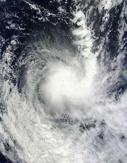
NASA's Aqua satellite passed over Tropical Cyclone Victoria on April 11 at 0320 UTC. The Moderate Resolution Imaging Spectroradiometer (MODIS) instrument aboard Aqua captured this visible image that showed strong thunderstorms around the center of circulation and in a band of thunderstorms wrapping around the eastern side of the storm. Credit: NASA Goddard MODIS Rapid Response Team<br>
When NASA’s Aqua satellite flew over Cyclone Victoria in the Southern Indian Ocean it captured a visible image of the storm and it appeared to look like the letter “J.” A band of thunderstorms wrapping into the center from the east of low-level center of circulation extended north, creating the appearance of the letter.
NASA's Aqua satellite passed over Tropical Cyclone Victoria on April 11 at 0320 UTC (April 10 at 11:20 p.m. EDT). The Moderate Resolution Imaging Spectroradiometer (MODIS) instrument aboard Aqua captured the visible image that showed strong thunderstorms around the center of circulation and in a band of thunderstorms wrapping around the eastern side of the storm.
On April 11 at 1500 UTC (11 a.m. EDT), Cyclone Victoria had maximum sustained winds near 50 knots (57.5 mph/92.6 kph). It was centered near 20.5 south latitude and 105.3 east longitude, about 530 nautical miles (610 miles/981.6 km) west-northwest of Learmonth, Australia. Victoria is moving to the south-southeast at 14 knots (16.1 mph/25.9 kph).
Wind shear is affecting Victoria, pushing the strongest convection (rising air that forms the thunderstorms that make up the tropical storm) and thunderstorms southeast of the center. The Joint Typhoon Warning Center forecasters noted that the wind shear is a result of a powerful jet stream located southwest of the cyclone. The wind shear is expected to continue increasing as Victoria tracks southeast, and sea surface temperatures will drop below the 80 degree Fahrenheit (26.6 Celsius) threshold needed to maintain a tropical cyclone. Those two factors are expected to weaken Victoria very quickly in the next day or two.
Text Credit: Rob Gutro
NASA's Goddard Space Flight Center, Greenbelt, Md.
Media Contact
All latest news from the category: Earth Sciences
Earth Sciences (also referred to as Geosciences), which deals with basic issues surrounding our planet, plays a vital role in the area of energy and raw materials supply.
Earth Sciences comprises subjects such as geology, geography, geological informatics, paleontology, mineralogy, petrography, crystallography, geophysics, geodesy, glaciology, cartography, photogrammetry, meteorology and seismology, early-warning systems, earthquake research and polar research.


Newest articles

Superradiant atoms could push the boundaries of how precisely time can be measured
Superradiant atoms can help us measure time more precisely than ever. In a new study, researchers from the University of Copenhagen present a new method for measuring the time interval,…

Ion thermoelectric conversion devices for near room temperature
The electrode sheet of the thermoelectric device consists of ionic hydrogel, which is sandwiched between the electrodes to form, and the Prussian blue on the electrode undergoes a redox reaction…

Zap Energy achieves 37-million-degree temperatures in a compact device
New publication reports record electron temperatures for a small-scale, sheared-flow-stabilized Z-pinch fusion device. In the nine decades since humans first produced fusion reactions, only a few fusion technologies have demonstrated…

