NASA satellite data confirm a stronger Tropical Storm Tomas, hurricane warnings up
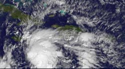
The GOES-13 satellite captured a visible image of Tropical Storm Tomas on Nov. 4 at 1231 UTC (8:31 a.m. EDT) on its way toward Haiti. GOES-13 is operated by NOAA. Credit: NOAA/NASA GOES Project
Infrared imagery helps scientists detect cold top temperatures within a tropical cyclone, and Tomas' cloud tops have grown colder over the last 24 hours. Tomas showed strong convective activity in his center as indicated by high thunderstorms that were as cold as -63 degrees Fahrenheit.
The colder the cloud tops, the higher and stronger the thunderstorms are that power the tropical cyclone. The infrared imagery was captured on Nov. 4 at 0659 UTC (2:59 a.m. EDT) by the Atmospheric Infrared Sounder (AIRS) instrument that flies aboard NASA's Aqua satellite.
At 8 a.m. EDT on Nov. 4 Tomas had maximum sustained winds near 50 mph, and further strengthening is expected as wind shear remains light and sea surface temperatures remain warm. Tomas was located about 150 miles south-southeast of Kingston, Jamaica and 305 miles southwest of Port Au Prince, Haiti near 15.9 North and 76.0 West. It was moving north-northwest near 6 mph, and had a minimum central pressure of 998 millibars.
Another indication of strengthening is falling atmospheric pressure. When air pressure falls a tropical cyclone is intensifying, and hurricane hunter aircraft detected a drop in atmospheric pressure at 8:30 a.m. EDT this morning within Tomas to 997 millibars.
A tropical storm warning is in effect for Jamaica as Tomas nears. Tropical Storm conditions are expected within 24 to 36 hours of the warning area. The warning was posted at 8 a.m. EDT on Nov. 4. Tropical storm warnings are also in effect for the south coast of the Dominican Republic from the Haiti border east to Barahona, and in Cuba, for the provinces of Guantanamo, Santiago de Cuba and Holguin.
Hurricane warnings are now in effect for Haiti, southeastern Bahamas and the Turks and Caicos Islands.
The National Hurricane Center (NHC) in Miami, Fla. is expecting very heavy rainfall amounts with Tomas. NHC stated that “Haiti and the Dominican Republic can expect 5 to 10 inches of rain, locally up to 15 inches. Jamaica may get 1 to 3 inches of rain. These rains could cause life-threatening flashfloods or mudslides. The Turks and Caicos Islands and the Bahamas could see 3 to 6 inches.”
In addition to the heavy rainfall, storm surges between 1 to 3 feet above normal tide levels can be expected in the warning area in areas of onshore flow.
Tropical Storm Tomas continues to track north-northwest toward the Windward Passage and eastern Hispaniola. Satellite imagery shows that scattered showers and thunderstorms that are associated with Tropical Storm Tomas are in the area between 15 and 19 degrees North and 67 to 79 West, covering a large area.
AIRS infrared satellite imagery showed a second area of showers and thunderstorms with strong convection, located to the southwest of Tomas. Computer models indicate that those showers are associated with a monsoon trough, or an elongated area of low pressure. That trough stretches a long distance from southwest of Tomas near 13 North and 78 West, west to Costa Rica and into the eastern Pacific Ocean.
A low- to mid-level ridge of high pressure (an elongated area of high pressure) is sitting over the western central Atlantic Ocean today is steering Tomas to the north-northwest and then north as it moves around the edge of the high. The high acts as a wall that Tomas can't break through, so it circles the high's perimeter.
Media Contact
More Information:
http://www.nasa.govAll latest news from the category: Earth Sciences
Earth Sciences (also referred to as Geosciences), which deals with basic issues surrounding our planet, plays a vital role in the area of energy and raw materials supply.
Earth Sciences comprises subjects such as geology, geography, geological informatics, paleontology, mineralogy, petrography, crystallography, geophysics, geodesy, glaciology, cartography, photogrammetry, meteorology and seismology, early-warning systems, earthquake research and polar research.


Newest articles

Superradiant atoms could push the boundaries of how precisely time can be measured
Superradiant atoms can help us measure time more precisely than ever. In a new study, researchers from the University of Copenhagen present a new method for measuring the time interval,…

Ion thermoelectric conversion devices for near room temperature
The electrode sheet of the thermoelectric device consists of ionic hydrogel, which is sandwiched between the electrodes to form, and the Prussian blue on the electrode undergoes a redox reaction…

Zap Energy achieves 37-million-degree temperatures in a compact device
New publication reports record electron temperatures for a small-scale, sheared-flow-stabilized Z-pinch fusion device. In the nine decades since humans first produced fusion reactions, only a few fusion technologies have demonstrated…

