NASA satellite gets 2 tropical cyclones in 1 shot
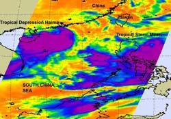
NASA's Aqua satellite captured this infrared image of 2 tropical cyclones from the AIRS instrument on June 22 at 17:53 UTC 1:53 p.m. EDT. The heaviest rainfall and strongest convection from Tropical Storm Meari (right) is currently over the Philippine Sea. The strongest thunderstorms (purple) in Haima (left) are mostly over the South China Sea and Hainan Island, China. Credit: NASA/JPL, Ed Olsen<br>
One of the instruments onboard NASA's Aqua satellite is the Atmospheric Infrared Sounder (AIRS). AIRS captures cloud top temperatures in tropical cyclones to determine the strength of convection and thunderstorms. The strongest thunderstorms have cloud tops with icy cold temperatures of -63F/-52C and are indicative of areas where rainfall rates could reach up to 2 inches / 50 mm per hour and both Meari and Haima had large areas of those very cold cloud top temperatures.
AIRS captured the image on June 22 at 17:53 UTC 1:53 p.m. EDT and it showed the heaviest rainfall and strongest convection (rapidly rising air that forms the thunderstorms that power a tropical cyclone) from Tropical Storm Meari is currently over the Philippine Sea and skirting the east coast of Luzon. The imagery showed the large area of strong thunderstorms (and convection) in Haima mostly over the South China Sea and Hainan Island, China.
Haima is still a tropical depression as its maximum sustained winds on June 23 at 1500 UTC (11 a.m. EDT) were near 30 knots (34 mph/55 kmh). Tropical storms have maximum sustained winds between 38 and 73 mph. It was located over Hainan Island, China, and about 235 nautical miles west-southwest of Hong Kong, China near 21.4 North and 109.6 East. Tropical Depression Haima is moving westward at 10 knots (11 mph/19 kmh).
The Joint Typhoon Warning Center does not expect Haima to strengthen into a tropical storm because of its interaction with land over Hainan Island, and its short track over the South China Sea between there and Vietnam where it is expected to make its final landfall. An orange alert in now in effect for North and South Korea as Tropical Depression Haima is tracking in that direction.
Meari is a tropical storm, and has maximum sustained winds near 40 knots (46 mph/78 kmh). It is centered to the east of Luzon, the Philippines and about 500 nautical miles south-southwest of Kadena Air Base, Japan. Meari is moving to the northwest at 12 knots (14 mph/22 kmh).
The Joint Typhoon Warning Center noted that Meari's center of circulation is elongated and there are “multiple minor vorticies developing and rotating cyclonically around the center.” During the morning hours on June 23, AIRS data and microwave satellite data showed that convection has consolidated around the center, helping to better pinpoint the center in this massive storm system.
As Meari continues on a northward track it will run into cooler sea surface temperatures in the Yellow Sea, they will weaken the tropical storm quickly.
Meari's center is forecast now to remain at sea and brush Taiwan, eastern China and make landfall in the southwestern area of North Korea this weekend.
NASA's Hurricane page: www.nasa.gov/hurricane
Media Contact
More Information:
http://www.nasa.govAll latest news from the category: Earth Sciences
Earth Sciences (also referred to as Geosciences), which deals with basic issues surrounding our planet, plays a vital role in the area of energy and raw materials supply.
Earth Sciences comprises subjects such as geology, geography, geological informatics, paleontology, mineralogy, petrography, crystallography, geophysics, geodesy, glaciology, cartography, photogrammetry, meteorology and seismology, early-warning systems, earthquake research and polar research.


Newest articles

Silicon Carbide Innovation Alliance to drive industrial-scale semiconductor work
Known for its ability to withstand extreme environments and high voltages, silicon carbide (SiC) is a semiconducting material made up of silicon and carbon atoms arranged into crystals that is…

New SPECT/CT technique shows impressive biomarker identification
…offers increased access for prostate cancer patients. A novel SPECT/CT acquisition method can accurately detect radiopharmaceutical biodistribution in a convenient manner for prostate cancer patients, opening the door for more…

How 3D printers can give robots a soft touch
Soft skin coverings and touch sensors have emerged as a promising feature for robots that are both safer and more intuitive for human interaction, but they are expensive and difficult…

