NASA's TRMM Satellite Calculates Hurricanes Fay and Gonzalo Rainfall
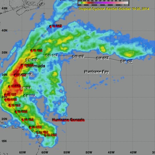
This rainfall analysis showed that Gonzalo generated several areas over the Atlantic Ocean where rainfall totals topped 12 inches (red). Fay's maximum rainfall appeared between 4 and 8 inches (green). Image Credit: NASA/SSAI, Hal Pierce
Tropical Storm Fay battered Bermuda on October 12, 2014 and became a hurricane after passing the island. The following Friday powerful Hurricane Gonzalo passed directly over the island on Friday October 17, 2014 causing flooding and damage to many structures.
The remnants of Gonzalo also pounded the British Islands with winds exceeding 70 mph causing the death of at least one person.
An analysis of rainfall was conducted on Fay and Gonzalo as they moved through the central Atlantic Ocean and over Bermuda. The analysis was based on near real time TRMM-based precipitation estimates (TMPA) that were produced by merging data from several satellites.
The analysis showed that Gonzalo generated several areas over the Atlantic Ocean where rainfall totals topped 12 inches (300 mm). Fay's maximum rainfall was between 4 and 8 inches (100-200 mm).
The rainfall estimates have been developed at the NASA Goddard Space Flight Center in Greenbelt, Maryland by the precipitation research team. The type of data used in this analysis is expected to be superseded by a Global Precipitation Measurement (GPM) mission product in late 2014.
TRMM is managed by NASA and the Japan Aerospace Exploration Agency. For more information about TRMM, visit: trmm.gsfc.nasa.gov. For more information about GPM, visit: www.nasa.gov/gpm.
Hal Pierce
SSAI/NASA's Goddard Space Flight Center
Media Contact
All latest news from the category: Earth Sciences
Earth Sciences (also referred to as Geosciences), which deals with basic issues surrounding our planet, plays a vital role in the area of energy and raw materials supply.
Earth Sciences comprises subjects such as geology, geography, geological informatics, paleontology, mineralogy, petrography, crystallography, geophysics, geodesy, glaciology, cartography, photogrammetry, meteorology and seismology, early-warning systems, earthquake research and polar research.


Newest articles

Silicon Carbide Innovation Alliance to drive industrial-scale semiconductor work
Known for its ability to withstand extreme environments and high voltages, silicon carbide (SiC) is a semiconducting material made up of silicon and carbon atoms arranged into crystals that is…

New SPECT/CT technique shows impressive biomarker identification
…offers increased access for prostate cancer patients. A novel SPECT/CT acquisition method can accurately detect radiopharmaceutical biodistribution in a convenient manner for prostate cancer patients, opening the door for more…

How 3D printers can give robots a soft touch
Soft skin coverings and touch sensors have emerged as a promising feature for robots that are both safer and more intuitive for human interaction, but they are expensive and difficult…

