NASA's IMERG measures flooding rainfall in Peru
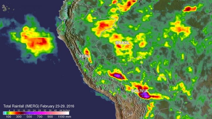
NASA's IMERG data collected from Feb. 23-29, 2016, were used to estimate rainfall totals over this area of South America. The highest rainfall total estimates for this period were over 700 mm (27.6 inches). These extreme rainfall total estimates were shown east of the Andes in southeastern Peru and Bolivia. Credits: ASA/JAXA/SSAI, Hal Pierce
GPM is the Global Precipitation Measurement mission, which is a satellite co-managed by NASA and the Japan Aerospace Exploration Agency and is used in NASA's IMERG data. GPM provides next-generation observations of rain and snow worldwide every three hours.
Extremely heavy rainfall was reported in northern Peru on February 26 and February 27, 2016. Thousands were made homeless and at least two people were reportedly killed from the severe weather. The strong El Niño was partially blamed for the abnormally high rainfall in that area.
NASA's IMERG data collected from February 23-29, 2016 were used to estimate rainfall totals over this area of South America. The highest rainfall total estimates for this period were over 700 mm (27.6 inches). These extreme rainfall total estimates were shown east of the Andes in southeastern Peru and Bolivia.
The satellites used in IMERG include DMSPs from the U.S. Department of Defense, GCOM-W from the Japan Aerospace Exploration Agency (JAXA), Megha-Tropiques from the Centre National D'etudies Spatiales (CNES) and Indian Space Research Organization (ISRO), NOAA series from the National Oceanic and Atmospheric Administration (NOAA), Suomi-NPP from NOAA-NASA, and MetOps from the European Organisation for the Exploitation of Meteorological Satellites (EUMETSAT).
All of the instruments (radiometers) onboard the constellation partners are intercalibrated with information from the GPM Core Observatory's GPM Microwave Imager (GMI) and Dual-frequency Precipitation Radar (DPR).
On March 3, Peru's National Meteorological and Hydrological Service said that rain was forecast to continue along the North Coast. The service said that in 10 hours, the Lancones (Piura) station recorded a total of 4.3 inches (110 mm), while in the city of Tumbes recorded 2.4 inches (60 mm). For forecasts, visit: http://www.
###
For more information about GPM, visit: http://www.
Media Contact
All latest news from the category: Earth Sciences
Earth Sciences (also referred to as Geosciences), which deals with basic issues surrounding our planet, plays a vital role in the area of energy and raw materials supply.
Earth Sciences comprises subjects such as geology, geography, geological informatics, paleontology, mineralogy, petrography, crystallography, geophysics, geodesy, glaciology, cartography, photogrammetry, meteorology and seismology, early-warning systems, earthquake research and polar research.


Newest articles

Bringing bio-inspired robots to life
Nebraska researcher Eric Markvicka gets NSF CAREER Award to pursue manufacture of novel materials for soft robotics and stretchable electronics. Engineers are increasingly eager to develop robots that mimic the…

Bella moths use poison to attract mates
Scientists are closer to finding out how. Pyrrolizidine alkaloids are as bitter and toxic as they are hard to pronounce. They’re produced by several different types of plants and are…

AI tool creates ‘synthetic’ images of cells
…for enhanced microscopy analysis. Observing individual cells through microscopes can reveal a range of important cell biological phenomena that frequently play a role in human diseases, but the process of…

