NASA's HS3 Hurricane Mission and Terra Satellite Take on Tropical Storm Dolly
The MODIS instrument aboard NASA's Terra satellite took this image of Tropical Storms Norbert (bottom left) in the Eastern Pacific and Dolly (right) in the Gulf of Mexico at 1:30 p.m. EDT on Sept. 2. Image Credit: NASA Goddard's MODIS Rapid Response Team
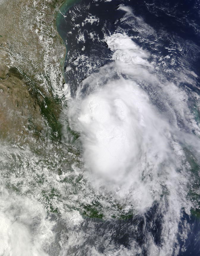
The MODIS or Moderate Resolution Imaging Spectroradiometer instrument aboard NASA's Terra satellite took an image of Tropical Storms Norbert in the Eastern Pacific and Dolly in the Gulf of Mexico at 1:30 p.m. EDT on Sept. 2. The image showed Dolly is a much more organized storm than Norbert, and revealed Dolly's strongest, towering thunderstorms around the center of circulation. Norbert is close to the western coast of Mexico, so the country has tropical storms to the east and west. The image was created by the NASA MODIS Rapid Response Team at NASA's Goddard Space Flight Center in Greenbelt, Maryland.
At 11 p.m. EDT on September 2, Dolly made landfall between Tampico and Cabo Rojo, near latitude 21.9 north and longitude 97.7 west.
One of NASA's unmanned Global Hawk aircraft number 872 surveyed Tropical Storm Dolly during the night-time hours of September 2 as part of NASA's latest hurricane airborne mission known as the Hurricane and Severe Storm Sentinel, or HS3 mission.
“We saw winds at low levels (near 850 millibars) up to about 35 to 40 knots (40 to 46 mph) and a reasonably depicted cyclonic circulation,” said HS3 Principal Investigator, Dr. Scott Braun of NASA's Goddard Space Flight Center in Greenbelt, Maryland. “The data at 150 millibars (high in the atmosphere) shows the strong outflow from the storm to the east and southeast.”
In the image, the dropsonde data gathered from NASA's Global Hawk were adjusted over the satellite image of the storm to compensate for the storm's movement. As a result, although the image makes dropsonde data look as if it were over eastern Mexico, there were no drops over the country. The data was just shifted to match the satellite image. All dropsondes were dropped over the Gulf of Mexico.
NASA's HS3 mission returned to NASA Wallops Flight Facility, Wallops Island, Virginia for the third year to investigate the processes that underlie hurricane formation and intensity change in the Atlantic Ocean basin. HS3 is a collaborative effort that brings together several NASA centers with federal and university partners.
By 8 a.m. EDT (1200 UTC) on September 3, Dolly had weakened to a depression with maximum sustained winds near 35 mph (55 kph). The National Hurricane Center (NHC) expects Dolly to weaken quickly and dissipate by the end of the day on September 3. Dolly was centered near latitude 21.7 north and longitude 98.8 west, about 65 miles (110 km) west-southwest of Tampico, Mexico. Dolly was moving toward the west near 8 mph (13 kph) and is expected to continue in that direction for the next day or so taking Dolly farther inland.
As with any tropical cyclone that makes landfall, heavy rainfall is always a concern. The NHC expects Dolly to produce rainfall amounts of 5 to 10 inches with isolated maximum amounts of 15 inches across much of Tamaulipas and Nuevo Leon…as well as northern Veracruz and eastern San Luis Potosi, Mexico through Wednesday evening. This rainfall is expected to cause life-threatening flash floods and mud slides in areas of mountainous terrain.
Rob Gutro
NASA's Goddard Space Flight Center, Greenbelt, Maryland
Media Contact
All latest news from the category: Earth Sciences
Earth Sciences (also referred to as Geosciences), which deals with basic issues surrounding our planet, plays a vital role in the area of energy and raw materials supply.
Earth Sciences comprises subjects such as geology, geography, geological informatics, paleontology, mineralogy, petrography, crystallography, geophysics, geodesy, glaciology, cartography, photogrammetry, meteorology and seismology, early-warning systems, earthquake research and polar research.


Newest articles

Properties of new materials for microchips
… can now be measured well. Reseachers of Delft University of Technology demonstrated measuring performance properties of ultrathin silicon membranes. Making ever smaller and more powerful chips requires new ultrathin…

Floating solar’s potential
… to support sustainable development by addressing climate, water, and energy goals holistically. A new study published this week in Nature Energy raises the potential for floating solar photovoltaics (FPV)…

Skyrmions move at record speeds
… a step towards the computing of the future. An international research team led by scientists from the CNRS1 has discovered that the magnetic nanobubbles2 known as skyrmions can be…

