NASA's GPM Satellite's Find Before Hurricane Simon Was Caught Rapidly Intensifying
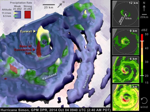
On Oct. 4 at 0940 UTC (5:40 a.m. EDT) GPM observations suggested Hurricane Simon was hiding a very compact eyewall hours before detection of rapid intensification of Hurricane Simon's surface winds. Image Credit: NASA/JAXA, Owen Kelley
On Oct. 4 at 0940 UTC (5:40 a.m. EDT) observations by the Ku-band radar on the GPM satellite suggested that the Eastern Pacific Ocean's Hurricane Simon was hiding a very compact eyewall hours before the National Hurricane Center detected rapid intensification of Simon's surface winds. The GPM satellite was launched in February of this year and is managed by both NASA and the Japan Aerospace Exploration Agency.
“This eyewall, a hollow ring of intense storms, had a diameter too small to be detected by other satellite instruments or with real time wind analyses that blend together such satellite observations,” said Owen Kelley of NASA's Goddard Space Flight Center in Greenbelt, Maryland.
Kelley analyzed the GPM data. “The intense convective cells (small, intense, short-lived rainstorms) that sometimes occur in compact eyewalls are known to be able to cause rapid intensification of hurricanes, but such small features are only easy to detect with radar.” That basically means radar-equipped aircraft or the GPM satellite must fly over the storm.
The NOAA P-3 aircraft did fly through Hurricane Simon on Oct. 4, but only after the National Hurricane Center determined that rapid intensification had already occurred.
In the coming years, GPM will enable scientists to study such unusual meteorological situations and may improve our understanding of hurricanes and of other kinds of severe storms. The GPM satellite will collect observations from a vast, but intermittent, sample of interesting meteorological situations, such as Hurricane Simon.
The GPM satellite will collect observations from the Arctic to the Antarctic circles and everything in between over the next three years, and perhaps longer. GPM will see features of the world's weather that otherwise might remain undetected.
At 5 a.m. EDT (2 a.m. PDT) on Oct. 4 the National Hurricane Center reported that Hurricane Simon was unable to form an eyewall that completely circled the eye because of a gap on the northeast side. Operational wind analyses that may have guided this statement were done at 11 p.m. on Oct. 3 and 3 a.m. PDT on Oct. 4. Those analyses showed a radius of maximum wind that was moderately large, 47 to 52 km (29 to 43 miles).
At 2:40 a.m. PDT, the GPM satellite saw that Hurricane Simon had a very compact eyewall. The eyewall had a radius of merely 10 km (6.2 miles) and hid a powerful convective cell. “The convective rain cell contained a 45 dBZ radar-reflectivity signal that reached 6.4 km (3.9 miles) altitude which is unusually high for such a strong signal in a hurricane eyewall,” Kelley said.
Compact eyewalls can increase the chance of rapid intensification because there is so little air trapped in the eye of the hurricane. The small volume of air in a small eye is easier to heat with the energy released when rain forms in the eyewall. Ultimately, this energy lowers the surface air pressure under the eye, and in response, the circling winds speed up at the ocean's surface.
At 8 a.m. PDT, the National Hurricane Center reported that rapid intensification had occurred and that a small eye was visible. At 10:20 a.m. PDT the NOAA P-3 aircraft flew through Hurricane Simon and reported that the maximum winds were 10 km away from the center of the eye, which suggests that the very compact eyewall that GPM had observed at 2:40 a.m. had persisted and may have been Hurricane Simon's primary eyewall (the region of maximum wind speed) throughout this period.
This aircraft overflight was the first time that the NOAA P-3 had flown through Hurricane Simon, making the GPM overflight earlier that day the only prior radar “fix” on Hurricane Simon's “heat engine,” its eyewall and eye. A detailed analysis would be needed to figure out how all of these observations illuminate Hurricane Simon's rapid intensification.
GPM data courtesy of NASA and JAXA.
For more information, visit: www.nasa.gov/gpm
Owen Kelley
NASA's Goddard Space Flight Center, Greenbelt, Maryland
Media Contact
All latest news from the category: Earth Sciences
Earth Sciences (also referred to as Geosciences), which deals with basic issues surrounding our planet, plays a vital role in the area of energy and raw materials supply.
Earth Sciences comprises subjects such as geology, geography, geological informatics, paleontology, mineralogy, petrography, crystallography, geophysics, geodesy, glaciology, cartography, photogrammetry, meteorology and seismology, early-warning systems, earthquake research and polar research.


Newest articles

“Nanostitches” enable lighter and tougher composite materials
In research that may lead to next-generation airplanes and spacecraft, MIT engineers used carbon nanotubes to prevent cracking in multilayered composites. To save on fuel and reduce aircraft emissions, engineers…

Trash to treasure
Researchers turn metal waste into catalyst for hydrogen. Scientists have found a way to transform metal waste into a highly efficient catalyst to make hydrogen from water, a discovery that…

Real-time detection of infectious disease viruses
… by searching for molecular fingerprinting. A research team consisting of Professor Kyoung-Duck Park and Taeyoung Moon and Huitae Joo, PhD candidates, from the Department of Physics at Pohang University…

