NASA's Aqua satellite sees Tropical Storm Ana still affecting Hawaii
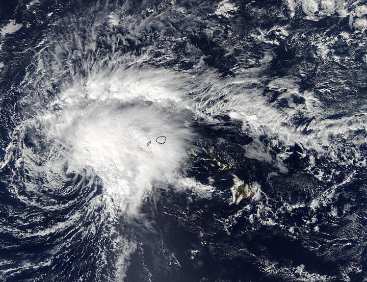
The MODIS instrument aboard NASA's Aqua satellite captured this image of Tropical Storm Ana over Hawaii on Oct. 20 at 23:55 UTC (7:55 p.m. EDT). Credit: NASA's Goddard MODIS Rapid Response Team
The Moderate Resolution Imaging Spectroradiometer or MODIS instrument aboard NASA's Aqua satellite captured a visible picture of Tropical Storm Ana over Hawaii on Oct. 20 at 23:55 UTC (7:55 p.m. EDT). The image showed that most of the clouds and showers were north and east of the center of circulation, pushed away from the center by strong southwesterly wind shear.
The MODIS image showed clouds in Ana's eastern quadrant covered the islands of Kauai and Niihau. Kauai is geologically the oldest of the main Hawaiian Islands and fourth largest of the main islands in the Hawaiian archipelago. Niʻihau or Niihau is the seventh largest of the inhabited Hawaiian Islands.
A tropical storm warning is still in effect for parts of the Papahanaumokuakea Marine National Monument from Nihoa to Maro Reef. The Central Pacific Hurricane Center (CPHC) noted that rainfall totals of 4 to 8, locally up to 12, inches are possible over the northwestern Hawaiian Islands near the center of the storm.
At 8 a.m. EDT (2 a.m. HST/1200 UTC) Ana's maximum sustained winds were near 50 mph (85 kph) and little change in strength is forecast through early Thursday. The center of tropical storm Ana was located near latitude 20.8 north and longitude 165.4 west. Ana's center was about 215 miles (345 km) south-southeast of French Frigate Shoals. The French Frigate Shoals is the largest atoll in the Northwestern Hawaiian Islands.
Ana was moving toward the west near 9 mph (14 kph) but the storm is expected to gradually become northerly through early Thursday, Oct. 22. The estimated minimum central pressure is 999 millibars.
CPHC warnings cited large swells produced by Ana will build across the northwest Hawaiian Islands through Wednesday. Surf produced by these swells will be dangerous along the southern and southeastern facing reefs of the northwest Hawaiian Islands.
The CPHC expects Ana to curve to the northeast and start transitioning into an extra-tropical storm on Friday, Oct. 24.
Media Contact
More Information:
http://www.nasa.govAll latest news from the category: Earth Sciences
Earth Sciences (also referred to as Geosciences), which deals with basic issues surrounding our planet, plays a vital role in the area of energy and raw materials supply.
Earth Sciences comprises subjects such as geology, geography, geological informatics, paleontology, mineralogy, petrography, crystallography, geophysics, geodesy, glaciology, cartography, photogrammetry, meteorology and seismology, early-warning systems, earthquake research and polar research.


Newest articles

Silicon Carbide Innovation Alliance to drive industrial-scale semiconductor work
Known for its ability to withstand extreme environments and high voltages, silicon carbide (SiC) is a semiconducting material made up of silicon and carbon atoms arranged into crystals that is…

New SPECT/CT technique shows impressive biomarker identification
…offers increased access for prostate cancer patients. A novel SPECT/CT acquisition method can accurately detect radiopharmaceutical biodistribution in a convenient manner for prostate cancer patients, opening the door for more…

How 3D printers can give robots a soft touch
Soft skin coverings and touch sensors have emerged as a promising feature for robots that are both safer and more intuitive for human interaction, but they are expensive and difficult…

